
The final part of our Western North Carolina weekend took us on the Blue Ridge Parkway from Asheville to Boone. This stretch of Parkway is about 100 miles in length, but it took us over eight hours to travel. Why? Well keep reading and find out!
For the entire flickr set (55 photos), head here.
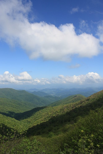
The Blue Ridge Parkway is known throughout the world for its incredible views and our first photo stop at the Lane Pinnacle overlook is no exception.
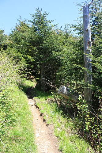
Stops like these wasn't what took the most time on this trip - it was three hiking stops we made this brilliant Sunday. The first of such was at Craggy Gardens. The Craggy Pinnacle Trail is a 0.7 mile trail to the top of Craggy Pinnacle. And once you reach the top, the views are breathtaking.
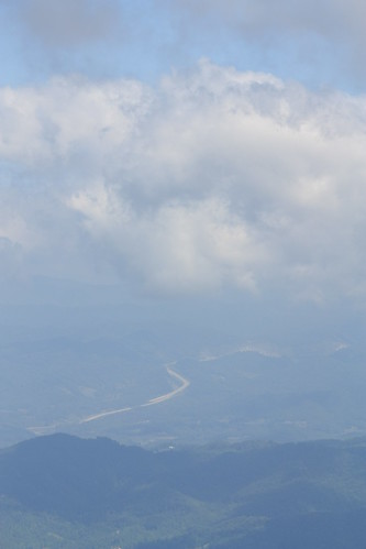
In the photo below, the road you see off in the distance is Interstate 26 near the Tennessee/North Carolina State Line.
So with the return hike, our total was 1.4 miles for the day so far.
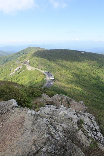
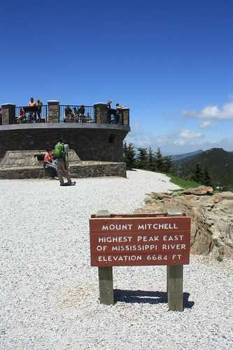
From Craggy Gardens, it is a short drive to Mount Mitchell State Park. Mount Mitchell at an elevation of 6684' is the highest point east of the Mississippi. Access to Mt. Mitchell is limited to following the Blue Ridge Parkway to NC 128 and following the slightly twisty road to the summit - as seen in the photo below.
But taking the Escape to the top of the mountain takes a little bit out of the adventure. So after lunch at the park restaurant, Maggie and I hiked to the summit along the Old Mitchell Trail.
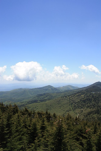
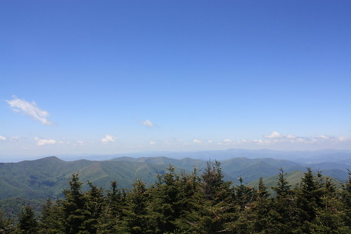
The 1.3 mile hike from the restaurant to the summit takes about one hour. The first 0.8 miles of the hike is strenuous and moderately technical. The last half mile of the trail is part of the statewide Mountains-to-Sea Trail. The hike is steep but not nearly as technical. The Old Mitchell Trail ends about 250 yards from the summit observation platform. The observation platform replaced an older observation tower within the past three years. The views are just amazing.
We then headed back on the Old Mitchell Trail to the Escape. The 2.6 mile round trip made it a total of four miles hiked at this point. This was my third piece of the Mountains-To-Sea trail that I have hiked. (I've also hiked a brief segment at Hanging Rock State Park and about 3.5 miles of the trail at Falls Lake here in Raleigh.)
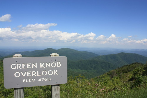
We made another photo stop at the Green Knob Overlook and gassed up off the Parkway on NC 80 in the tiny community of Busick.
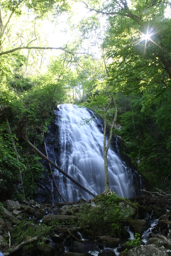
Our final Parkway stop was at Crabtree Meadows and a hike down to the spectacular Crabtree Falls. The hike down to the falls from Crabtree Meadows is 0.9 miles one way. It's all downhill to the falls and a rather steep at times return - but upon your first glimpse of the 70' falls, it's well worth it.
The 1.8 mile down and back hike gave us 5.8 miles for the day. (In case you haven't figured it our by now, Maggie and I have started to take more to hiking in the recent months.) By the time we were finished at Crabtree Meadows it was after five, and although we wanted to make a stop at Linville Falls, that would have to wait for our next trip to the mountains. We followed the Parkway to US 321 just outside of Blowing Rock, grabbed a quick dinner, hit US 421 and followed that to I-40 home.
It was a great three day weekend in the Western North Carolina mountains and we're already taking notes on what to do on our next trip that way in the not to distant future.
For the entire flickr set (55 photos), head here.
The Blue Ridge Parkway is known throughout the world for its incredible views and our first photo stop at the Lane Pinnacle overlook is no exception.
Stops like these wasn't what took the most time on this trip - it was three hiking stops we made this brilliant Sunday. The first of such was at Craggy Gardens. The Craggy Pinnacle Trail is a 0.7 mile trail to the top of Craggy Pinnacle. And once you reach the top, the views are breathtaking.
In the photo below, the road you see off in the distance is Interstate 26 near the Tennessee/North Carolina State Line.
So with the return hike, our total was 1.4 miles for the day so far.
From Craggy Gardens, it is a short drive to Mount Mitchell State Park. Mount Mitchell at an elevation of 6684' is the highest point east of the Mississippi. Access to Mt. Mitchell is limited to following the Blue Ridge Parkway to NC 128 and following the slightly twisty road to the summit - as seen in the photo below.
But taking the Escape to the top of the mountain takes a little bit out of the adventure. So after lunch at the park restaurant, Maggie and I hiked to the summit along the Old Mitchell Trail.
The 1.3 mile hike from the restaurant to the summit takes about one hour. The first 0.8 miles of the hike is strenuous and moderately technical. The last half mile of the trail is part of the statewide Mountains-to-Sea Trail. The hike is steep but not nearly as technical. The Old Mitchell Trail ends about 250 yards from the summit observation platform. The observation platform replaced an older observation tower within the past three years. The views are just amazing.
We then headed back on the Old Mitchell Trail to the Escape. The 2.6 mile round trip made it a total of four miles hiked at this point. This was my third piece of the Mountains-To-Sea trail that I have hiked. (I've also hiked a brief segment at Hanging Rock State Park and about 3.5 miles of the trail at Falls Lake here in Raleigh.)
We made another photo stop at the Green Knob Overlook and gassed up off the Parkway on NC 80 in the tiny community of Busick.
Our final Parkway stop was at Crabtree Meadows and a hike down to the spectacular Crabtree Falls. The hike down to the falls from Crabtree Meadows is 0.9 miles one way. It's all downhill to the falls and a rather steep at times return - but upon your first glimpse of the 70' falls, it's well worth it.
The 1.8 mile down and back hike gave us 5.8 miles for the day. (In case you haven't figured it our by now, Maggie and I have started to take more to hiking in the recent months.) By the time we were finished at Crabtree Meadows it was after five, and although we wanted to make a stop at Linville Falls, that would have to wait for our next trip to the mountains. We followed the Parkway to US 321 just outside of Blowing Rock, grabbed a quick dinner, hit US 421 and followed that to I-40 home.
It was a great three day weekend in the Western North Carolina mountains and we're already taking notes on what to do on our next trip that way in the not to distant future.
Comments