Originally when I was planning out my trip I wanted to take all of California State Route 35 given it has a single-lane segment of highway. Unfortunately the single-lane section was wiped out in a mudslide (it still is as I write this on 11/8/17) and I had to settle for CA 35 from CA 9 north to Great Highway in San Francisco.

CA 35 was one of the original Signed State Highways in 1934 but had a number of 5 at the time. CA 5 was changed to CA 35 in the 1964 State Highway renumbering to avoid a numbering duplication with Interstate 5. Prior to 1964 CA 5 was part of Legislative Route 55 which was created in 1919. CA 35 is 54 miles in length stretching from a southern terminus at CA 17 to a northern terminus at CA 1 in San Francisco.
For the most part CA 35 known as Skyline Boulevard and a large portion of the route follows the peaks of the Santa Cruz Range north to San Francisco. When I arrived at the junction of CA 35 and CA 9 both routes were closed due to slides south to CA 17.

The views along CA 35/Skyline of San Francisco Bay are particularly nice. CA 35 essentially had no cars on it with all the road closures leading up to it.


Views of the Pacific are a little harder to get from pull-outs but they can be found.

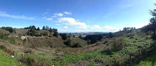
Really there a ton of scenic pull-outs, especially south of CA 84.

There was some minor road damage from from slides on CA 35 approaching CA 84.


North of CA 84 San Francisco starts to come into view as CA 35 begins to lose elevation approaching the city.

I'm not sure how far south the scenic part of CA 35 goes but it does end when the route muliplexes on CA 92 dropping out of the Santa Cruz Range.

There was a detour directing CA 35 north traffic onto I-280 at exit 34. Normally CA 35 jumps onto I-280 at exit 36 heading north. For whatever reason the normal route of CA 35 wasn't closed and I used it to hop on I-280.


Skyline Boulevard was sectioned up at some point to make way for I-280 between 1970 and 1977.
1970 State Highway Map
1977 State Highway Map
CA 35 jumps off I-280 at exit 41 and widens out to an expressway.


CA 35 briefly becomes a freeway crossing CA 1. CA 35 continues on Skyline Boulevard along the coast before looping back east to CA 1 on Sloat Boulevard where it terminates.

Since I couldn't do a route clinch I turned off of CA 35 onto Great Highway to take the back way towards the Golden Gate Bridge and downtown.

The change from CA 5 to CA 35 can be seen on the 1963 and 1964 state highway maps.
1963 State Highway Map
1964 State Highway Map
Pretty much everything I talk about with LRN history usually comes from CAhighways.org. As usual the site has an excellent stub on CA 35.
CAhighways.org on CA 35

CA 35 was one of the original Signed State Highways in 1934 but had a number of 5 at the time. CA 5 was changed to CA 35 in the 1964 State Highway renumbering to avoid a numbering duplication with Interstate 5. Prior to 1964 CA 5 was part of Legislative Route 55 which was created in 1919. CA 35 is 54 miles in length stretching from a southern terminus at CA 17 to a northern terminus at CA 1 in San Francisco.
For the most part CA 35 known as Skyline Boulevard and a large portion of the route follows the peaks of the Santa Cruz Range north to San Francisco. When I arrived at the junction of CA 35 and CA 9 both routes were closed due to slides south to CA 17.

The views along CA 35/Skyline of San Francisco Bay are particularly nice. CA 35 essentially had no cars on it with all the road closures leading up to it.


Views of the Pacific are a little harder to get from pull-outs but they can be found.

Really there a ton of scenic pull-outs, especially south of CA 84.

There was some minor road damage from from slides on CA 35 approaching CA 84.


North of CA 84 San Francisco starts to come into view as CA 35 begins to lose elevation approaching the city.

I'm not sure how far south the scenic part of CA 35 goes but it does end when the route muliplexes on CA 92 dropping out of the Santa Cruz Range.


There was a detour directing CA 35 north traffic onto I-280 at exit 34. Normally CA 35 jumps onto I-280 at exit 36 heading north. For whatever reason the normal route of CA 35 wasn't closed and I used it to hop on I-280.


Skyline Boulevard was sectioned up at some point to make way for I-280 between 1970 and 1977.
1970 State Highway Map
1977 State Highway Map
CA 35 jumps off I-280 at exit 41 and widens out to an expressway.


CA 35 briefly becomes a freeway crossing CA 1. CA 35 continues on Skyline Boulevard along the coast before looping back east to CA 1 on Sloat Boulevard where it terminates.

Since I couldn't do a route clinch I turned off of CA 35 onto Great Highway to take the back way towards the Golden Gate Bridge and downtown.

The change from CA 5 to CA 35 can be seen on the 1963 and 1964 state highway maps.
1963 State Highway Map
1964 State Highway Map
Pretty much everything I talk about with LRN history usually comes from CAhighways.org. As usual the site has an excellent stub on CA 35.
CAhighways.org on CA 35
Comments