
Last Summer the Tioga Pass Road over the Sierra Nevada Mountains in Yosemite National Park opened late due to the heavy snow pack from the previous winter. Approaching the start of July the Park Service finally had cleared the road to Tioga Pass. That being the case I headed up shortly after the 4th of July holiday during a lull in the tourist season.

Part 1; the history of the Tioga Pass Road
Tioga Pass first obtained noteworthiness when a mining expedition discovered silver at the Sheepherder Mine on Tioga Ridge during 1860. The 1860 discovery of silver was not initially exploited and the finding largely fell into obscurity. The Sheepherder silver claim was rediscovered in 1875 (1874 according to the Division of Highways) by William Brusky Jr. Brusky wasn't able to obtain a sizeable piece of ore to bring to an assay until 1877. Claims at Tioga Ridge were formally organized in 1878 which led to the establishment of the Tioga Mining District. By 1880 the mining community of Dana at the site of the Great Sierra Mine had become large enough to warrant Post Office Service. By 1881 the Great Sierra Consolidated Silver Company ("Great Sierra Company") bought out all the mining claims on Tioga Ridge.
Tioga Pass can be seen as "McLanes Pass" on the 1868 California Geological Survey Map of the Sierra Nevada Mountains near the vicinity of Yosemite Valley.
1868 California Geoloical Survey Map

The mines at Tioga Ridge were initially accessible by way of trails through Lundy Canyon and Bloody Pass. The "Great Sierra Wagon Road" was proposed by the Great Sierra Company which had an estimated cost of $17,000 dollars in 1881 to build a road from the Big Oak Flat Road near Crane Flat east to the Tioga Peak mines. In 1882 the Great Sierra Company authorized a survey for a wagon road and railroad to the mines of Tioga Ridge which was completed by August during said year. In July of 1882 the California & Yosemite Short Line Railroad was incorporated with the intended goal of also building a rail line to the Tioga Mining District.
By September of 1883 the Great Sierra Wagon Road had been completed east from the Big Oak Flat Road to the Tioga Mining District. The Great Sierra Wagon Road never truly saw it's intended traffic load as the Tioga Mining District shuttered operations during mid-year 1884. The Great Sierra Wagon Road was intended to be a tolled facility but there is no records of any money actually being collected. As the years wore on the Great Sierra Wagon Road remained in periodic use but began to fall into disrepair due to a lack of maintenance.
In 1896 an appropriations bill to purchase the Great Sierra Wagon Road was proposed but never gained traction in the House of Representatives. In 1899 the Army was directed by Congress to survey the Great Sierra Wagon Road. The Army determined the Great Sierra Road while in a state of disrepair had been well engineered with an average gradient of 3%. A recommendation was made by the Yosemite National Park commissioners that the Great Sierra Wagon Road could be repaired for $2,000 dollars versus the cost of constructing a new highway for an estimated cost of approximately $61,000 dollars. Yosemite National Park thusly formally recommended that the Federal Government acquire the Great Sierra Wagon Road.
The Tioga Pass Road can be seen ending at the Tioga Mining District on the 1906 Norris Peters Map of Yosemite National Park. A trail over Mono Pass can be seen southeast of Tioga Pass.
1906 Norris Peters Map of Yosemite National Park


In 1899 what would become Legislative Route 40 ("LRN 40") was added to the State Highway System. The original definition of what became LRN 40 according to CAhighways.org called for:
"locating and constructing a free wagon road from the Mono Lake Basin to and connecting with a wagon road called the "Tioga Road" and near the "Tioga Mine"
The Department of Public Works first considered building the eastern extension of the Tioga Road to Mono Basin first via an established pack trail over Bloody Pass. By 1902 a new route via Lee Vining Canyon had been selected and construction began. The September 1950 California Highways & Public Works cites that by 1910 construction through Lee Vining Canyon to the Tioga Mine had yet been completed to State standards. A later Division of Highways guide (seen below) cites that LRN 40 east of Tioga Pass was completed during 1910.
September 1950 California Highways & Public Works


In 1911 the Federal Government brought a lawsuit against the franchise holders of the Great Sierra Wagon (referred to as the "Old Tioga Road"). The Federal suit argued that the Tioga Road had been long abandoned and sought to condemn the franchise rights so it could be incorporated as a Park Road. Ultimately the law suit found that the owners of the Tioga Road had maintained it enough that their claims to ownership were valid.
The completed Tioga Pass Road can be seen in detail on the 1914 USGS Map of Yosemite National Park.
1914 USGS Map of Yosemite National Park


The concept of the Federal Government acquiring the Tioga Road withing Yosemite National Park was not revisited until 1915. Stephen Mather, Assistant to the Secretary of the Interior sought to improve automotive access to Yosemite National Park. Mather learned that the purchase price of the Tioga Road within Yosemite National Park was $15,500 dollars. Mather along with several other private contributors purchased the Tioga Road with Yosemite. The Tioga Road was subsequently purchased by the Federal Government for $10 dollars on April 10th, 1915. The Tioga Pass Road was repaired and was opened to automotive traffic on July 28th, 1915. The first year the Tioga Pass Road was opened to traffic only 190 cars entered Yosemite National Park via Tioga Pass.
Much of the above early history of the Tioga Pass Road within Yosemite National Park was cited from Yosemite.ca article on Tioga Pass.
Yosemite.ca on the Tioga Pass Road
According to CAhighways.org in 1915 Legislative Chapter 306 and 396 changed the definition of LRN 40 to include all of the segments Tioga Pass Road and Big Oak Flat Road which were not in within the boundary of Yosemite National Park:
"that portion of the Great Sierra Wagon Road, better known as the Tioga Road, lying without the boundary of Yosemite National Park, providing that the portion within the park is taken over by the federal government." Chapter 396 added "that certain toll road in Tuolumne and Mariposa counties known as the Big Oak Flat and Yosemite Toll Road beginning at a point near the former location of Jack Bell Sawmill in Tuolumne Cty and extending thence in an E-ly direction through a portion of Mariposa Cty at Hamilton Station, thence again into Tuolumne Cty, past the Hearden Ranch, Crocker Station, Crane Flat, and Gin Flat to the boundary line of the original Yosemite Grant near Cascade Creek"
More on LRN 40 can be found on CAhighways.org:
CAhighways.org on Legislative Route 40
The original alignment of the Tioga Pass Road was considerably different than the modern highway. The original Tioga Pass Road diverged from the Big Oak Flat Road at the South Fork Tuolumne River via modern Evergreen Road. The Tioga Pass Road followed Evergreen Road to Aspen Valley Road. The Tioga Pass Road entered Yosemite National Park via what is now Aspen Valley Road to Aspen Valley. From Aspen Valley the original Tioga Pass Road followed the Old Tioga Road Trail to the White Wolf Lodge. From the White Wolf Lodge the Tioga Pass Road followed modern White Wolf Road back to the modern Tioga Pass Road. The original alignment of the completed Tioga Pass can be seen on the 1917 California State Automobile Association Map.
1917 California State Automobile Association Map

The below Gribblenation article features the original Big Oak Flat Road and Tioga Pass Road entrances to Yosemite National Park:
Old California State Route 140 and California State Route 120 entrances to Yosemite National Park
Early LRN 40 on the Tioga Pass Road and Big Oak Flat Road outside Yosemite National Park can be seen on the 1918 Division of Highways State Map of California.
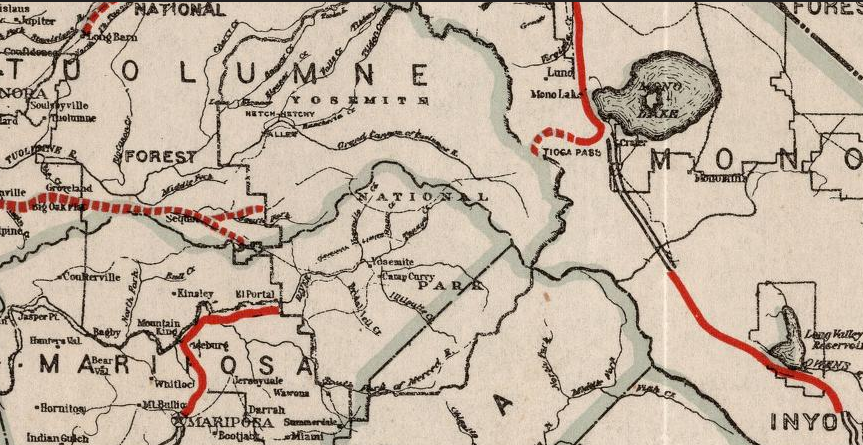
In an August of 1934 Department of Public Works Guide the Sign State Routes were announced. CA 120 was announced as being signed east of Groveland through Yosemite National Park via the Tioga Pass Road. CA 140 was announced as entering Yosemite National Park via the El Portal Road and connecting to CA 120 through the park by way of the Big Oak Flat Road.

The 1935 Division of Highways Map of Tuolumne County shows in detail State Highway maintenance approaching the boundary of Yosemite National Park. The lower path is the route of CA 140 on the Big Oak Flat Road whereas the top path is CA 120 on the Tioga Pass Road. State maintenance of CA 140 on the Big Oak Flat Road is shown ending at the Crane Flat Ranger Station whereas CA 120 maintenance ends at the Aspen Valley Ranger Station. I marked the paths of CA 120 and CA 140 with shields for graphical clarity.

The below graphic illustrates the original alignments of CA 120/CA 140 on the Big Oak Flat and Tioga Pass Road. Red denotes the path of the Big Oak Flat Road whereas blue denotes the Tioga Pass Road.

Zooming in on the above graphic the original crossing over the South Fork Tuolumne River where CA 120 split from the Big Oak Flat Road onto the Tioga Pass Road can be seen.

In 1940 the current route of the Big Oak Flat Road in Yosemite National Park was opened between Crane Flat and Yosemite Valley. The Old Big Oak Flat Road from Tuolumne Grove to Yosemite Valley was largely converted into a one-way scenic alternate.
According to the yosemite.ca library article above the Tioga Pass Road was realigned to the new Big Oak Flat Road near Tuolumne Grove east towards White Wolf Road (referred to as McSwain Meadows) in July of 1939. Interestingly it doesn't appear that CA 120 nor CA 140 were immediately changed with the realignment of the Tioga Pass Road. Sometime between 1942 and 1944 CA 140 was cut back to the El Portal Entrance of Yosemite on the Merced River while CA 120 was rerouted off of Evergreen Road onto the Big Oak Flat Road where CA 120 via the current Carlon Day Use Area. The changes are reflected on the 1942 and 1944 Division of Highways State Maps.
1942 Division of Highways State Map

1944 Division of Highways State Map

The Tioga Pass Road is featured in the July 1941 California Highways & Public Works. The article cites a realignment of CA 120/Tioga Pass Road east from the Yosemite National Park boundary to Lake Ellory.


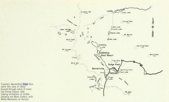
The Tioga Pass Road in Lee Vining Canyon is featured as the cover of the May/June 1944 California Highways & Public Works.

The Tioga Pass Road between Lake Ellory and Lake Tioga is featured in the July/August 1944 California Highways & Public Works.


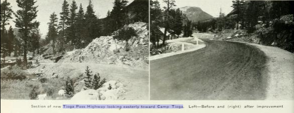
The paving of the CA 120/LRN 40 portion of the Tioga Pass Road is discussed in the November/December 1950 California Highways & Public Works.


It wasn't until 1956/1957 that the New Big Oak Flat Road between Evergreen Road and Crane Flat was opened to traffic. After the new alignment of the Big Oak Flat Road between Evergreen Road and Crane Flat opened the Old Big Oak Flat Road from the Carlon Day Use Area to Tuolumne Grove was abandoned or turned into trails. The portion of the Big Oak Flat Road from Crane Flat to the Tuolumne Grove became part of the Tioga Pass Road. This second shift in the alignment of the Big Oak Flat Road can be seen on the 1957 Division of Highways State Map.

CA 120/Tioga Pass Road through Lee Vining Canyon is displayed in the July/August 1960 California Highways & Public Works.
July/August 1960 California Highways & Public Works

The November/December 1965 California Highways & Public Works cites that two miles of the CA 120 expressway project on the Tioga Pass Road were completed. Seven additional miles of expressway on CA 120/Tioga Pass Road are cited to be under construction. The new bridge at the top of Lee Vining Canyon is shown under construction.
November/December 1965 California Highways & Public Works


The history of the Tioga Pass Road is covered in detail in two articles in the January/February 1966 California Highways & Public Works. The rediscovery of the Sheepherder Mine of Tioga Ridge are cited as 1874 as opposed to 1875 as cited in the Yosemite.ca article above. The LRN 40 portion of the Tioga Pass Road is cited to have been complete by 1910. The first car over Tioga Pass is cited to have passed through circa 1913. The expressway straightening of CA 120/Tioga Pass Road east of the Yosemite National Park boundary to US 395 is cited to have an anticipated completion sometime in 1967.
January/February 1966 California Highways & Public Works


Part 2; a drive on the Tioga Pass Road
I made my way up CA 41 and the Wawona Road early in the morning to the overlook of the Big Oak Flat Road approaching Yosemite Valley. Note; some of the photos below are from the summer of 2020 and were taken for continuity purposes to illustrate the Tioga Pass Road.

Given the holiday crowds were checked out after the 4th and it was early in the morning I pretty much had the Wawona Tunnel in addition to overlook to myself.


I looped around Southside Drive, El Captain Drive, and Northside Drive in Yosemite Valley to El Portal Road. Leaving Yosemite Valley on the El Portal Road I noticed that a new MUTCD compliant US 395 shield was posted with a "To" placard. The previous US 395 shield disappeared sometime in the winter. I turned right on the Big Oak Flat Road which climbs away from the Merced River towards the Tioga Pass Road.


There are a series of three tunnels on northwest Big Oak Flat Road before Tioga Pass Road is reached at Crane Flat.


Yosemite National Park signs CA 120 as though it exists within the Park Boundaries. From Crane Flat CA 120 signage indicates the highway is carried west on the Big Oak Flat Road and east by way of the Tioga Pass Road. There is gas available at Crane Flat, as the Tioga Pass Road eastbound begins traffic is alerted the next services are 56 miles away.


The modern Tioga Pass Road east of Tuolumne Grove passes by numerous segments of the Old Big Oak Flat, most notably the campground road to Tamarak Flat.


The Tioga Pass Road quickly ascends to over 8,000 feet above sea level and intersects it's old alignment at White Wolf Road.


The Lubken Lake Trailhead is located on Tioga Pass Road east of White Wolf Road.

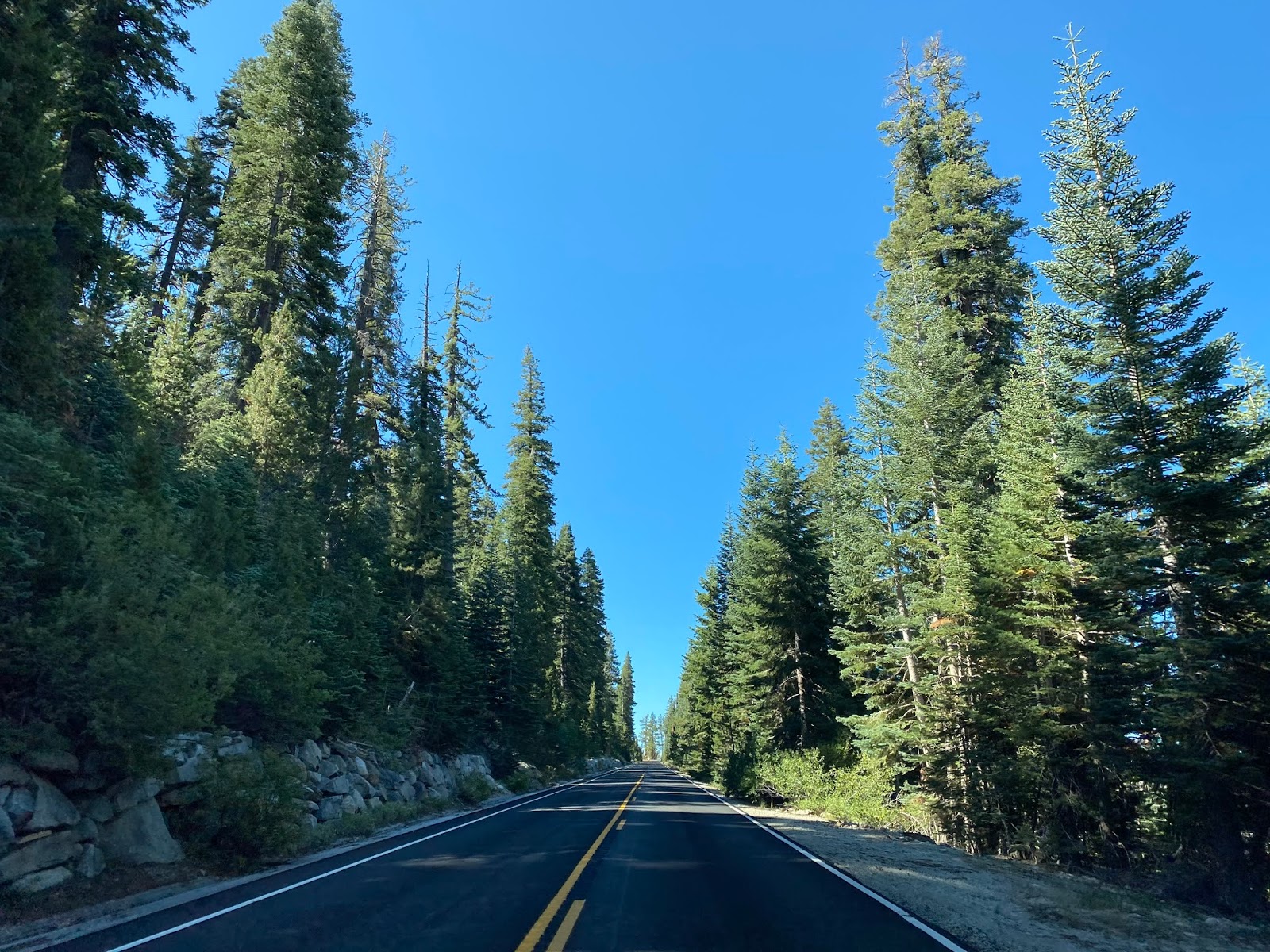
East of the Lubken Lake Trailhead the Tioga Pass Road starts to become more curvy and has wide sweeping views of the Sierras. There was a small rain shower passing overhead as I climbed higher in elevation.


Approaching Olmstead Point the Tioga Pass Road passes by the Yosemite Creek, Ten Lakes, Porcupine Creek, and May Lake Trailheads. Tioga Pass Road eastbound through this segments tends to run cliff-face through the terrain.


Half Dome wasn't obstructed by the rain shower from Olmstead Point.


Tenaya Lake can be seen to the east along the Tioga Pass Road from Olmstead Point.

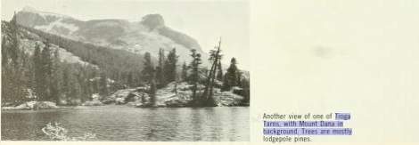
Tioga Pass Road runs along the north shore of Tenaya Lake which is at 8,150 feet above sea level. The Sunrise Trail can be found at Tenaya Lake.


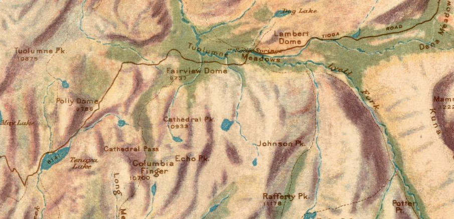
Approaching Tuolumne Meadows the Tioga Pass Road was a little soggy but nothing severe. Tuolumne Meadows was very wet from all the fresh snow melt. The Tioga Pass Road much like every other road in Yosemite National Park has markers meant to point out areas of interest.

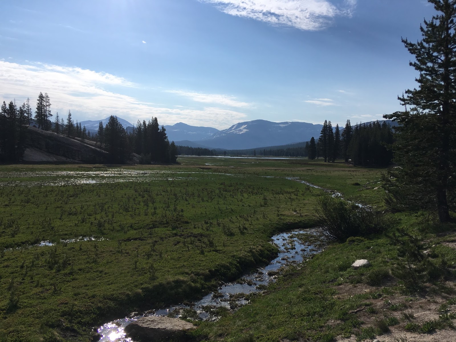


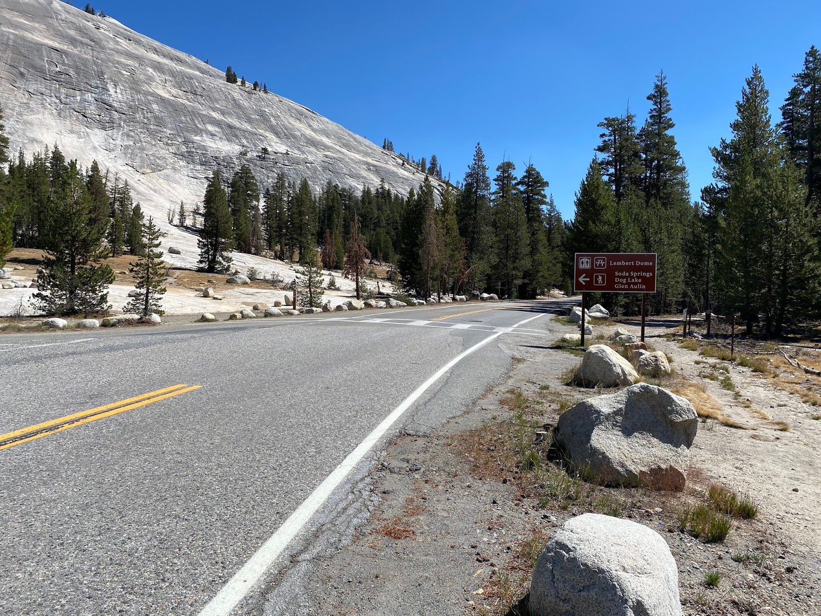
Speed limits in Tuolume Meadows generally range from 25-35 MPH due to the Visitor Center and numerous trailheads. The Tioga Pass Road crosses the Tuolumne River approaching the trailheads at Lempert Dome.


Tioga Pass Road follows the Dana Fork out of Tuolumne Meadows heading east approaching Tioga Pass.

Tioga Pass is located at the entrance station for Yosemite National Park. There is a sign indicating you are at 9,945 feet above sea level but it isn't really well placed as it can be found on the park entrance building.

There is an informal overlook of Tioga Lake from the pass that had plenty of snow just within Inyo National Forest as the Tioga Pass Road becomes CA 120.


The first CA 120 shield can be seen at the Mono County Line.


CA 120/Tioga Pass Road is signed as having 7 miles of curves ahead.


Approaching Lee Vining Canyon the Tioga Pass Road starts to open up on the 7% drop to Mono Lake.


There is a nice plaque at Lee Vining Canyon detailing the history of the Tioga Pass Road.

The current bridge in Lee Vining Canyon.

The Old Tioga Pass Road can be found at the 9,000 feet above sea level placard descending CA 120/Tioga Pass Road into Lee Vining Canyon.


The 7% grade is sustained on CA 120/Tioga Pass Road dropping through Lee Vining Canyon. The road is signed at 50 MPH but I tend to use 3rd gear so I don't ride my brakes.


Mono Lake comes into view on CA 120/Tioga Pass Road approaching US 395.

The Tioga Pass Road ends at 6,781 feet above sea level in Lee Vining
at US 395. CA 120 East multiplexes US 395 South before cutting east again towards US 6.

Comments
1) While maybe not signed, Tioga Pass Road is Hwy. 120 within the park boundary. It does not stop at the entrance stations.
2) What you describes as interesting mile markers are actually roadside description markers for notable locations. They are numbered numerically and are related to a guidebook you can purchase at all park bookstores. The “T” stands for Tioga Pass, while there are additional roadside markers for key locations in Yosemite Valley (V) and along Wawona Road (W).