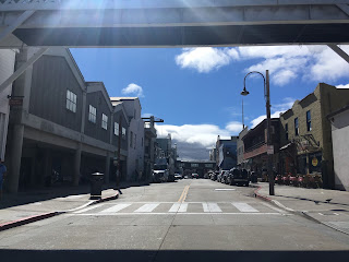
On my way back from CA 68 and Asilomar Beach I made my way to Cannery Row for old times sake. Cannery Row was part of what was one of biggest trips my family took in all the way back in 1993 when we were residing in Connecticut. The 1993 trip started in San Francisco and ended in San Diego, most of it was taken along California State Route 1. Cannery Row in Monterey was part of the 1993 vacation due to it being a name tourist destination and location of the Monterey Bay Aquarium which had opened in 1984. I thought it would be interesting to take some comparison pictures which honestly really didn't look much different despite the passage of time.
Cannery Row was part of the original alignment of 17 Mile Drive back in 1901. I'm not all that familiar with the backstory of the Cannery but it appears to have been split off at least by the early 1920s since the sardine canning industry appears to have begun as early as 1902. Cannery Row actually has a website and has some good historical references that go into much more detail than I can:
Cannery Row History
The canning industry appears to have gone defunct by 1973 and Cannery Row became more of a tourist destination. Pretty much Cannery Row has kept the historic motif which really has been helped by the Monterey Bay Aquarium drawing tourist interest.


As for that family trip, after Monterey we made our way south on CA 1 through Big Sur. I really wish that I had more photos from that trip of Big Sur but it was the age of having to take your film to the photo booth or using a Polaroid which didn't really lend to having anything in volume. Really it was my first experience on the West Coast and sure was an eye opener having lived only in Michigan and Connecticut up to that point. I pretty much knew even then as a kid that I wanted to be on the West Coast and made good on it back in the early 2000s moving across the country the week after I graduate high school. Weird to see that Cannery Row looks exactly as how I remembered it even after a quarter century, even stranger that I never thought to go revisit despite being in Monterey as often as I am.
Comments