I first visited California State Route 75 back in 2010 while on a weekend trip out of Phoenix. Recently in 2019 I revisited CA 75 while on a trip out of Central California.

CA 75 is a 13 mile north/south state highway which loops from I-5. CA 75 loops from I-5 in San Diego southward via the San Diego-Coronado Bridge over San Diego Bay, the City of Coronado, Silver Strand and back to I-5 in the outskirts Imperial Beach. CA 75 wasn't one of the original Signed State Highways from 1934 but rather was unsigned Legislative Route 199. LRN 199 became CA 75 at least by 1938 as it appears on state highway maps.
1938 California State Highway Map
Prior to 1968 CA 75 had a north terminus in Coronado. The 1935 California Divisions of Highways Map indicates the route of LRN 199/CA 75 essentially is the same as it is today.
1935 California Divisions of Highways San Diego County Map
Originally CA 75 ended on Orange Avenue at 1st Street in Coronado at the San Diego-Coronado Ferry. The San Diego-Coronando Ferry would cross San Diego Bay and end at US 101 at Market Street. In 1968 Orange Avenue between 4th Street and 1st Street was transferred to CA 282 while the definition of CA 75 was moved to the incomplete San Diego-Coronado Bridge. Below are photos of what was the San Diego-Coronado Ferry in modern day Centennial Park.


During the 1964 State Highway Renumbering the definition of CA 75 was extended past it's southern terminus in Imperial Beach onto unbuilt LRN 281. LRN 281 was a 1959 State Highway adoption according to CAhighways.org.
1963 State Highway Map City Insert
1964 State Highway Map City Insert
By 1969 CA 75 had been extended to I-5 in San Diego via the San Diego-Coronado Bridge was completed. The change can be seen on the 1969 and 1970 State Highway Maps.
1969 State Highway Map
1970 State Highway Map
According to CAhighways.org the LRN 281 section of CA 75 was eventually redesignated as CA 117 in 1976. The unbuilt LRN 281 extension of CA 75 can be seen on the 1975 State Highway Map along with a partially completed CA 117 appearing the 1977 edition.
1975 State Highway Map City Insert
1977 State Highway Map City Insert
CA 117 would later be renumbered as CA 905 by 1985 according to CAhighways.org. Interestingly CA 117 still appears on the 1986 State Highway Map City Insert.
1986 State Highway Map City Insert
CA 905 finally appears replacing CA 117 on the 1988 State Highway Map City Insert.
1988 State Highway Map City Insert
Recently Caltrans has become interested in relinquishing segments of CA 75. In 2018 the California Transportation Commission authorized relinquishing CA 75 within Imperial Beach. More recently Caltrans has proposed relinquishing CA 75 within the City of Coronado. More information can be found on CAhighways.org.
CAhighways.org on CA 75
At the time I wasn't so great at taking road photos but I thought that I got a couple decent ones of the San Diego-Coronado Bridge. When the Coronado Bridge opened it was a tolled facility. Originally tolling on the Coronado Bridge was supposed to end in 1986 when the original bond was paid. The last toll on the Coroando Bridge was collected back in 2002 which was far after the first bond was paid. I actually did a run along the bay down to the Hotel Del Coronado.


The reason I ran down to the Hotel Del Coronado was due to the parking being something absurd like $15 dollars an hour even back in 2010. There wasn't a fee to walk into the Hotel or use the beach grounds along the Silver Strand. The Hotel Del Coronado was completed back in 1888 and if memory serves correct it has something in the neighborhood of 700 rooms. There were some decent view to be had looking northeast towards Point Loma to boot.


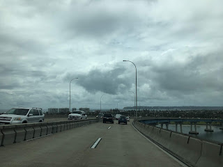
As stated in the intro in 2019 I returned to Coronado and CA 75. My approach to Coronado was via the Coronado Bridge via I-5 south.


Crossing the Coronado Bridge offers a fantastic view of the City of Coronado, Naval Air Station North Island and Point Loma. The central signage of the bridge somewhat ominously offers suicide assistance. The Coronado Bridge is unfortunately marred by over 400 suicides which have occurred since the span opened.


CA 75 sound still enters the toll facility upon entering Coronado. There has been some proposals to re-toll the Coronado Bridge to fund a tunnel across San Diego Bay.


CA 75 splits onto 3rd Street in Coronado before meeting CA 282. CA 282 continues westbound towards Naval Air Station North Island whereas CA 75 south turns onto Orange Avenue towards downtown Coronado.


CA 75 south on Orange Avenue meets the western terminus of CA 282 at 4th Street. Traffic returning to San Diego via CA 75 north and the Coronado Bridge is directed onto 4th Street.


CA 75 south continues on Orange Avenue towards the Silver Strand and Hotel del Coronado. CA 75 south passes by numerous City of Coronado public facilities as it passes through downtown Coronado.


At Adella Avenue CA 75 south on Orange Avenue passes by the Hotel del Coronado.


Past the Hotel del Coronado the route of CA 75 south becomes Silver Strand Boulevard and continues onward to Imperial Beach. On my recent trip I eventually turned around at Ponoma Avenue in front of Hotel del Coronado and returned to San Diego via CA 75 north over the Coronado Bridge.


During my visit to Coronado in 2019 I did run the Bayshore Bikeway a couple times. I stopped by the underside of the Coronado Bridge at sunrise one morning for some scenic photos.


CA 75 is a 13 mile north/south state highway which loops from I-5. CA 75 loops from I-5 in San Diego southward via the San Diego-Coronado Bridge over San Diego Bay, the City of Coronado, Silver Strand and back to I-5 in the outskirts Imperial Beach. CA 75 wasn't one of the original Signed State Highways from 1934 but rather was unsigned Legislative Route 199. LRN 199 became CA 75 at least by 1938 as it appears on state highway maps.
1938 California State Highway Map
Prior to 1968 CA 75 had a north terminus in Coronado. The 1935 California Divisions of Highways Map indicates the route of LRN 199/CA 75 essentially is the same as it is today.
1935 California Divisions of Highways San Diego County Map
Originally CA 75 ended on Orange Avenue at 1st Street in Coronado at the San Diego-Coronado Ferry. The San Diego-Coronando Ferry would cross San Diego Bay and end at US 101 at Market Street. In 1968 Orange Avenue between 4th Street and 1st Street was transferred to CA 282 while the definition of CA 75 was moved to the incomplete San Diego-Coronado Bridge. Below are photos of what was the San Diego-Coronado Ferry in modern day Centennial Park.


During the 1964 State Highway Renumbering the definition of CA 75 was extended past it's southern terminus in Imperial Beach onto unbuilt LRN 281. LRN 281 was a 1959 State Highway adoption according to CAhighways.org.
1963 State Highway Map City Insert
1964 State Highway Map City Insert
By 1969 CA 75 had been extended to I-5 in San Diego via the San Diego-Coronado Bridge was completed. The change can be seen on the 1969 and 1970 State Highway Maps.
1969 State Highway Map
1970 State Highway Map
According to CAhighways.org the LRN 281 section of CA 75 was eventually redesignated as CA 117 in 1976. The unbuilt LRN 281 extension of CA 75 can be seen on the 1975 State Highway Map along with a partially completed CA 117 appearing the 1977 edition.
1975 State Highway Map City Insert
1977 State Highway Map City Insert
CA 117 would later be renumbered as CA 905 by 1985 according to CAhighways.org. Interestingly CA 117 still appears on the 1986 State Highway Map City Insert.
1986 State Highway Map City Insert
CA 905 finally appears replacing CA 117 on the 1988 State Highway Map City Insert.
1988 State Highway Map City Insert
Recently Caltrans has become interested in relinquishing segments of CA 75. In 2018 the California Transportation Commission authorized relinquishing CA 75 within Imperial Beach. More recently Caltrans has proposed relinquishing CA 75 within the City of Coronado. More information can be found on CAhighways.org.
CAhighways.org on CA 75
At the time I wasn't so great at taking road photos but I thought that I got a couple decent ones of the San Diego-Coronado Bridge. When the Coronado Bridge opened it was a tolled facility. Originally tolling on the Coronado Bridge was supposed to end in 1986 when the original bond was paid. The last toll on the Coroando Bridge was collected back in 2002 which was far after the first bond was paid. I actually did a run along the bay down to the Hotel Del Coronado.


The reason I ran down to the Hotel Del Coronado was due to the parking being something absurd like $15 dollars an hour even back in 2010. There wasn't a fee to walk into the Hotel or use the beach grounds along the Silver Strand. The Hotel Del Coronado was completed back in 1888 and if memory serves correct it has something in the neighborhood of 700 rooms. There were some decent view to be had looking northeast towards Point Loma to boot.


As stated in the intro in 2019 I returned to Coronado and CA 75. My approach to Coronado was via the Coronado Bridge via I-5 south.


Crossing the Coronado Bridge offers a fantastic view of the City of Coronado, Naval Air Station North Island and Point Loma. The central signage of the bridge somewhat ominously offers suicide assistance. The Coronado Bridge is unfortunately marred by over 400 suicides which have occurred since the span opened.


CA 75 sound still enters the toll facility upon entering Coronado. There has been some proposals to re-toll the Coronado Bridge to fund a tunnel across San Diego Bay.


CA 75 splits onto 3rd Street in Coronado before meeting CA 282. CA 282 continues westbound towards Naval Air Station North Island whereas CA 75 south turns onto Orange Avenue towards downtown Coronado.


CA 75 south on Orange Avenue meets the western terminus of CA 282 at 4th Street. Traffic returning to San Diego via CA 75 north and the Coronado Bridge is directed onto 4th Street.


CA 75 south continues on Orange Avenue towards the Silver Strand and Hotel del Coronado. CA 75 south passes by numerous City of Coronado public facilities as it passes through downtown Coronado.


At Adella Avenue CA 75 south on Orange Avenue passes by the Hotel del Coronado.


Past the Hotel del Coronado the route of CA 75 south becomes Silver Strand Boulevard and continues onward to Imperial Beach. On my recent trip I eventually turned around at Ponoma Avenue in front of Hotel del Coronado and returned to San Diego via CA 75 north over the Coronado Bridge.


During my visit to Coronado in 2019 I did run the Bayshore Bikeway a couple times. I stopped by the underside of the Coronado Bridge at sunrise one morning for some scenic photos.


Comments