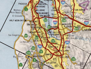
Legacy California State Route 17; CA 13 (i), CA 17, the Nimitz Freeway, I-880, the Richmond-San Rafael Bridge, and I-580
Back in 2018 I had an opportunity to drive the entirety of California State Route 17. California State Route 17 was once one of California's important State Highways with segments eventually becoming part of Interstate 880 and Interstate 580.

Part 1; a drive on CA 17
CA 17 is 27 mile State Highway from CA 1 in Santa Cruz north to the junction of I-280/I-880 in San Jose. CA 17 is a heavily trafficked highway with approximately 54,000 to 197,000 vehicles a day in the 1990s according to CAhighways.org. CA 17 was once a far larger route previously which traversed the corridors now occupied by I-880, I-80, and I-580 to reach US 101 in San Rafael. CA 17 even had an unbuilt segment that could have reached the outskirts of Point Reyes. CA 17 is somewhat infamous due to it's current haggard expressway design in the Santa Cruz Range which begins north of CA 1.

From CA 1 I jumped onto CA 17 north which still has Oakland as a control city 75 miles northward.


Unfortunately I was on a time limit and the lighting conditions weren't the best for my camera in the Santa Cruz Range. After a very brief freeway section north of Santa Cruz CA 17 drops to a divided expressway with at-grade intersections. Santas Village Road actually went to a theme park of the same name in Scott's Valley which apparently had opened in 1958 which has since closed.


CA 17 is known for sharp curves in the Santa Cruz Range. The speed limit is posted at 50 MPH and 35 MPH for trucks. There are several large advisory speed signs which are no doubt in place where drivers have hit the center divider. The southern terminus of CA 35 is at an overpass junction on Summit Road but my photos were too blurred up to capture a clear image.


At Bear Creek Road most of the at-grade junctions disappear and CA 17 begins to drop towards Los Gatos and San Jose. The yellow lights are apparently for Cats Restaurant which had been a source of traffic control issues. My understanding is that the high accident rate out of Cats forced Caltrans to route traffic leaving to head southbound to Bear Creek Road. Cats is the location where the 35 MPH truck speed limit ends.


In Los Gatos CA 17 junctions CA 9 which is on Saratoga-Los Gatos Road.


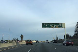
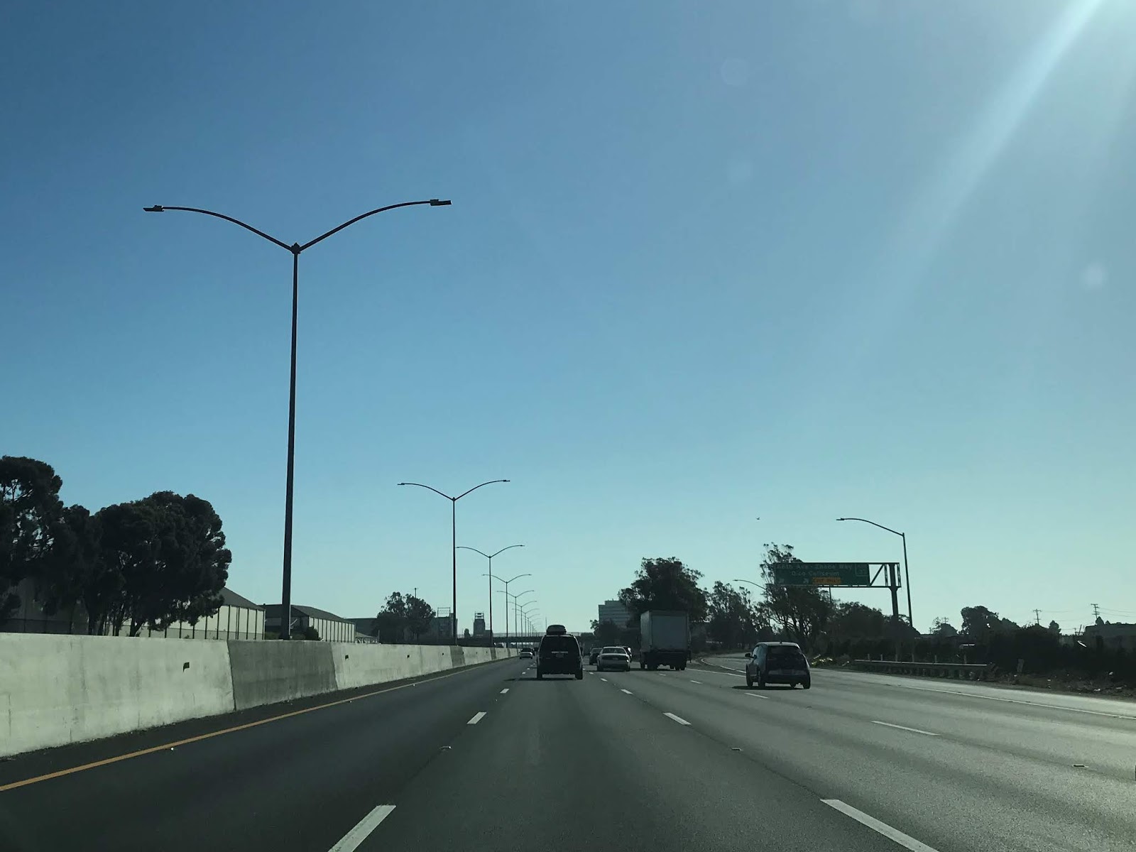
In north Los Gatos CA 17 junctions the CA 85 freeway. There are actually several 511 travel time signs but this was only one I caught a clear picture of.


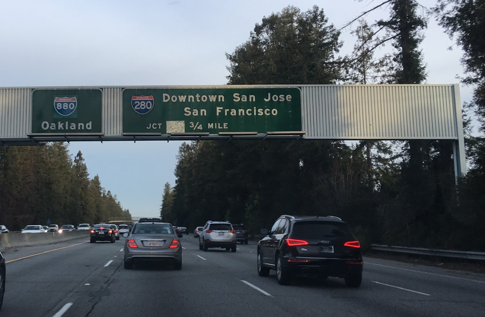
CA 17 northbound passes through Campbell before terminating at I-280/I-880 in San Jose. I didn't notice any "END" placards at the end of CA 17 but the old button-copy Interstate shields on the guide signs were a nice throwback. The path of travel north on CA 17 continues onto I-880 on the Nimitz Freeway.


Part 2; the history of CA 17 and it's breaking apart into Interstate segments
Today the most exciting thing about CA 17 is the Santa Cruz Range expressway segment. As noted CA 17 used to be far more grand in scope before the advent of the Interstate era as mentioned in the intro. Originally CA 17 was signed as CA 13 back in 1934 but was likely changed to CA 17 by 1936. CA 13 can be seen announced as a new State Highway aligned between Santa Cruz north to San Rafael in an August 1934 Department of Public Works Publication.


CA 13 replaced US 101E north of San Jose (which in turn replaced US 48 between San Jose and Hayward) as it last appears on the 1934 Division of Highway State Map. CA 13 may have been replaced with CA 17 due to the former number being unpopular due to the possible association with bad luck.
1934 State Highway Map City Insert


Conjecture has it that CA 13 would have followed LRN 69 through Alameda and the Posey Tube to downtown Oakland. CA 17 may have been intended to be a new Sign State Route that would have been aligned completely on LRN 105. The numbering of CA 13 as stated above seems to have had caused some controversy which may have led to it being replaced by CA 17. The 1935 Gousha Highway Map of California lends some evidence to this theory and seems to show CA 17 aligned on LRN 69 through Alameda. Interestingly US 101A is shown being routed on LRN 69 and LRN 105 from Oakland south to San Jose.

Part 2A; the early alignment of CA 17
The alignment of CA 17 between Santa Cruz and San Jose was part of Legislative Route 5 which was adopted as part of the 1909 First State Highway Bond Act. CA 17 from San Rafael to Point San Quentin was added to the State Highway System as part of LRN 69 in 1925. LRN 69 was expanded to include a segment between Richmond and San Jose in 1933. That said, the original definition of CA 13 and by extension of CA 17 had it aligned on LRN 69 from Richmond to Oakland, LRN 105 (adopted in 1933 as a State Highway between Half Moon Bay and Oakland according to CAhighways) from Oakland to San Leandro, and LRN 69 from San Leandro to San Jose. CAhighways.org details the history of CA 13/CA 17 and the previous alignment of the Santa Cruz Range in Santa Clara County before the modern expressway built.
The 1935 Division of Highways Maps of the Bay Area Counties provide insight into the original alignment of CA 17. Much of the original CA 17 alignment is still used today as local roads in Santa Cruz County. North of Santa Cruz the alignment on the 1935 Santa Cruz County Map shows CA 17 on; Market Street, Branciforte Drive, Granite Creek Road, and Glenwood Drive to the Santa Clara County Line. The above alignment can be viewed on the 1935 Division of Highways Map.
1935 Santa Cruz County Highway Map

Within Santa Clara County the alignment of CA 17 north of Los Gatos to San Jose followed; Main Street, Los Gatos Boulevard, Bascom Avenue, San Carlos Street, and likely Race Street to US 101 which would have been at the cross street of The Alameda and Santa Clara Street. From US 101 the alignment or early CA 17 split north via 13th Street. CA 17 followed 13th Street northward to Oakland Road and Main Street in Milpitas. From Milpitas CA 17 northbound followed Main Street to Warm Springs Road (which used to connect directly) and Alameda County Line. The alignment of CA 17 within Santa Clara County can be viewed below on the 1935 Division of Highways Map.
1935 Santa Clara County Highway Map

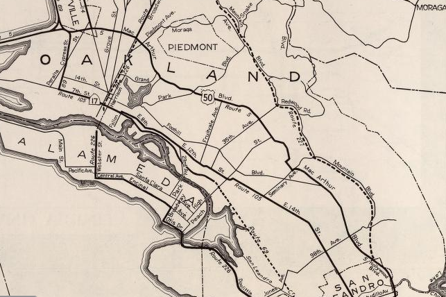
Within Alameda County the original surface alignment of CA 17 followed Warm Springs Boulevard to Warm Springs. Within Warm Springs CA 17 would have turned on what is now Warm Springs Court, Lopes Court, Old Warm Springs Road to Fremont Boulevard. CA 17 northbound followed Fremont Boulevard through Irvington to the City of Fremont. CA 17 north continued on Fremont Boulevard to Alvarado where it turned onto what is now Hesperian Boulevard. CA 17 northbound followed Hesperian Boulevard through Mount Eden to San Lorenzo. Within San Lorenzo CA 17 northbound turned onto Lewelling Boulevard to Washington Avenue. CA 17 northbound followed Washington Avenue into downtown San Leandro where it turned onto 14th Street.
From Hayward CA 17 northbound followed 14th Street as it became International Boulevard in Oakland. Within Oakland CA 17 northbound followed International Boulevard to 44th Avenue. From 44th Avenue CA 17 northbound made a quick transition onto 12th Street. Approaching downtown Oakland CA 17 northbound transitioned from 12th Street on to 8th Street. CA 17 northbound likely followed 8th Street to a jog on Fallon Street to 7th Street where it probably turned toward onto Broadway. CA 17 likely had an original signed terminus at Oakland City Hall where it would have met US 40 at San Pablo Avenue.
The construction of the Bay Bridge led to some changes in the State Highways within Oakland but much of the original alignment of CA 17, LRN 69, and LRN 105 can be viewed on the 1935 Division of Highways Maps below:
1935 Division of Highways Map of Alameda County

Note; the 1935 Division of Highways Map of Oakland below shows the routing of CA 17 extended to the Bay Bridge approach where it met US 40/US 50. The new approach for CA 17 was on LRN 105 on 7th Street west of Broadway and LRN 69 on Cypress Street to US 40/US 50.
1935 Division of Highways Map of Oakland

Despite the initial legislative definition of CA 13 having a terminus in San Rafael it doesn't appear that early CA 17 existed on local roadways in Contra Costa County nor on LRN 69 in Marin County. LRN 69 was connected to Contra Costa County via the Richmond-San Rafael Ferry which operated from Point San Quentin and Castro Point. LRN 69 in Marin County appears to have connected from Point San Quentin west to US 101 via Francisco Boulevard which can be seen on the 1935 Division of Highways Map.

Part 2B; modernizing CA 17/LRN 5 over the Santa Cruz Mountains
Much of CA 17/LRN 5 is shown to be moved to a modernized grade within the Santa Cruz County portion of the Santa Cruz Mountains on the April 1937 California Highways and Public Works Guide.


Open Bids for completing the remaining segment of CA 17/LRN 5 over Santa Cruz Mountains from Oaks Road to Los Gatos were announced in the November 1937 California Highways and Public Works Guide. The article contains the proposed new alignment of CA 17/LRN 5 over the crest of the Santa Cruz Mountains to Los Gatos.


Grading of the final portion of the modern route of CA 17/LRN 5 is discussed in the June 1938 California Highways and Public Works Guide. The original grade of LRN 5 over the Santa Cruz Mountains is cited to have been completed by 1911 with paving beginning in 1921.


The 1938 Division of Highways Map is the first to display CA 17 and the Sign State Routes.
1938 Division of Highways Map

The final leg of the new Los Gatos-Santa Cruz alignment of CA 17/LRN 5 is shown to be complete in the July 1939 California Highways and Public Works Guide.


Part 2C; the evolution of the East Shore Freeway into the Nimitz Freeway
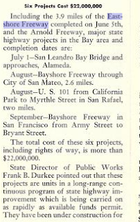
Construction of the East Shore Freeway south of the Bay Bridge began in 1946 with the purpose of replacing much of the surface alignment of CA 17. The new route of LRN 69 and the East Shore Freeway first appears on the 1948 Division of Highways State Map City Insert of Oakland.

The planning stages of the East Shore Freeway are discussed in the January/February 1946 California Highways and Public Works Guide. The East Shore Freeway is described as being planned in 1940 and would incorporate part of Bay Bridge approach of US 40. The route of the East Shore Freeway was planned in overall scope as a new alignment between Richmond and San Jose. Initially budgeted for 1941-1943 delays in the East Shore Freeway project were borne from the United States entering World War II. The East Shore Freeway south of the Bay Bridge is described to be in the planning phases with the first part of the anticipated project being planned from the Oakland City Limit to Oak Street.


The opening the initial phase of the East Shore Freeway in Oakland is described in the July/August 1946 California Highways and Public Works Guide.


The first segment of CA 17/LRN 69 on the East Shore Freeway opened on July 22, 1949 between Oak Street in downtown Oakland and 23rd Avenue. This new segment of the East Shore Freeway first appears on the 1950 Division of Highways State Map City Insert of Oakland.

The opening ceremony of the East Shore Freeway between Oak Street and 23rd Avenue is covered in the July/August 1949 California Highways and Public Works Guide.


By June 1, 1950 the East Shore Freeway was extended to 98th Street and first appears on the 1951 Division of Highways State Map City Insert of Oakland.

The East Shore Freeway is described as being nearly complete to 98th Street in the March/April 1950 California Highways and Public Works Guide.


On June 13, 1952 the East Shore Freeway was extended to Lewelling Boulevard in San Lorenzo and can be seen on the 1953 Division of Highways State Map City Insert. Note; much of Washington Avenue in San Leandro appears to be deleted from the State Highway System by 1953.

The East Shore Freeway reaching San Lorenzo is covered in the May/June 1952 California Highways and Public Works Guide.


On June 5, 1953 the East Shore Freeway was extended to Legislative Route 105 on Jackson Street (future CA 92) in Hayward which can be seen on the 1954 Division of Highways State Map.

The opening of the East Shore Freeway to Jackson Street is covered in the July/August 1953 California Highways and Public Works Guide.

By July 2, 1954 the East Shore Freeway opened north of US 101 on a bypass of Milpitas to Warm Springs. This new segment of CA 17/CA 9 on the East Shore Freeway can be seen on the 1955 Division of Highways State Map.

On June 11, 1957 the Cypress Street Viaduct connected the East Shore Freeway to the Bay Bridge on a limited access grade. On November 14, 1957 the East Shore Freeway was extended to Beard Road near Fremont. These new additions to the East Shore Freeway can be seen on the 1958 Division of Highways State Map.

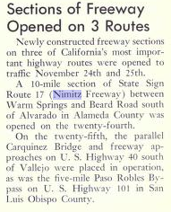
The prospects of a freeway alignment of CA 17 between Los Gatos and Santa Cruz are described in the March/April 1958 California Highways and Public Works Guide. A bypass of the Los Gatos business district on a 2.1 mile freeway alignment of CA 17 is described as opening in 1957.

On November 24, 1958 the gap in the East Shore Freeway between Alvarado and Warm Springs opened to traffic. Thusly, traffic on CA 17 between San Jose and Oakland could travel on a limited access freeway for the first time. The East Shore Freeway would soon be renamed the Nimitz Freeway in honor of World War II Fleet Admiral Chester W. Nimitz. The completed Nimitz Freeway between San Jose and Oakland can be seen on the 1959 Division of Highways State Map.

The final leg of the East Shore Freeway between El Cerrito and San Jose is cited to have an anticipated completion of late 1958 or early 1959 in the March/April 1958 California Highways and Public Works Guide.


The final gap in the East Shore Freeway (referred to for the first time as the Nimitz Freeway) is cited to be completed between Alvarado and Warm Springs in the November/December 1958 California Highways and Public Works Guide.
 On the 1961 Division of Highways State Map CA 17 is shown moved to a limited access grade from US 101 in San Jose south to Los Gatos.

The freeway grade of CA 17 between San Jose and Los Gatos opened fully on June 21, 1960 according to the July/August 1960 California Highways and Public Works Guide.


Part 2D; the Richmond-San Rafael Bridge
On September 1, 1956 The Richmond-San Rafael Bridge was opened to traffic which replaced the ferry route between Point San Quentin and Castro Point. On the 1957 Division of Highways State Map LRN 69 is shown to be extended to the Richmond-San Rafael Bridge. By 1960 state maintenance of the Richmond-San Rafael Bridge is shown along with CA 17 extended to US 101 in San Rafael. CA 17 initially utilized a surface routing through Richmond via Hoffman Boulevard and Cutting Boulevard to reach the Richmond-San Rafael Bridge.
1957 Division of Highways Map

1960 Division of Highways Map

The opening the Richmond-San Rafael Bridge is covered in the September/October 1956 California Highways and Public Works Guide.


The route of CA 17 is stated to be extended over the Richmond-San Rafael Bridge to US 101 in 1957 according to the March/April 1957 California Highways and Public Works Guide. Funding to build CA 17 from the western approach of the Richmond-San Rafael Bridge as a freeway to US 101 are cited as being ear marked for the 1958-59 fiscal years.


Part 2E; the final evolution of CA 17 and the advent of Interstate 880/Interstate 580
Initially the CA 17 designation survived the 1964 renumbering intact north of San Jose and had a proposed extension northwest to near Point Reyes Station via the corridor of Sir Francis Drake Boulevard to a proposed extension of CA 37. The unbuilt segment of CA 17 towards Point Reyes Station was brought into the State Highway System as a 1959 extension of LRN 69. Note; former surface segments of CA 17 became CA 185 and CA 262 immediately after the 1964 State Highway Renumbering. I-680 was put on a temporary multiplex of CA 17 on the Nimitz Freeway between Warm Springs and San Jose. CA 17 was also assigned as the temporary legislative route on it's former surface segment between Warm Springs and San Jose.
1964 Division of Highways Map
On the 1965 Division of Highways Map CA 238 is shown signed on former CA 17 between Warm Springs and San Jose along with it being refined as part of Legislative Route 680.

The 1975 Caltrans State Highway Map is the first edition to shown I-680 moved off of CA 17 and the Nimitz Freeway to it's own grade between Warm Springs south to San Jose.

In 1981 CA 17 between San Jose and Oakland was transferred to I-880 according to CAhighways. In 1984 CA 17 between Oakland and San Rafael was transferred to I-580 which apparently was proposed in 1983 as I-180 according to CAhighways. Due to new Interstate designations CA 251 replaced unbuilt CA 17 between US 101 and planned CA 37 near Point Reyes Station. All these changes appear for the first time on the 1986 Caltrans State Map.
1986 Caltrans State Map


Interestingly former CA 17 between I-80 and US 101 was transferred to I-580 prior to a new freeway grade being built through Richmond. This can be seen on the City Insert of the 1986 Caltrans State Highway Map where the route of I-580 is shown as an expressway with a planned freeway route.

The John T. Knox Freeway alignment of I-580 through Richmond began construction in 1987 and was completed by 1991. The John T. Knox Freeway is shown nearly completed on the 1990 Caltrans State Highway Map City Insert.

During the October 17, 1989 Loma Prieta Earthquake the Cypress Street Viaduct collapsed which resulted in 42 deaths. In interim traffic headed to I-880 southbound on the Nimitz Freeway was required to detour onto I-980. The gap in I-880 over what had been the Cypress Street Viaduct reopened in July 1997 but it wouldn't repairs wouldn't be completed until 2001. The photo below shows the collapsed Cypress Street Viaduct after the 1989 Loma Prieta Earthquake.

Part 3; exploring the early north terminus of LRN 105 (and likely CA 17) in downtown Oakland
In early 2019 I visited the original west terminus of US Route 40 in what is now Frank Ogawa Plaza in downtown Oakland. Originally US 40 had terminated on San Pablo Avenue at the intersection of 14th Street and Broadway. In 1933 the Legislature allowed the Division of Highways to maintain roadways in cities which resulted in a glut of new routes being adopted. As noted above LRN 105 was one of the many route adoptions of 1933 and it had an original north terminus in downtown Oakland via Broadway at the intersection of US 40/San Pablo Avenue and 14th Street. Early major roadways in Oakland can be observed on the 1934 Division of Highways State Map City Insert.

Note; US 101E likely entered Oakland from the ferry docks on San Francisco Bay. US 101E was likely signed on 7th Street and Broadway where it would have met US 40 at San Pablo Avenue. This rough alignment can be seen in the 1934 City Insert above. Given the Sign State Routes were announced in the August 1934 California Highways and Public Works guide it is likely that the north terminus of CA 13 (and by proxy CA 17) was intended to terminate at Broadway at US 40 in downtown Oakland. It is highly likely CA 13 nor CA 17 were never actually field signed to US 40 in downtown Oakland. LRN 105 on Broadway is shown to no longer be under State Maintenance on Broadway on the 1935 Division of Highways Map of Oakland (seen in Part 2). Ultimately CA 17/LRN 105 would be realigned to US 40/US 50 approaching the Bay Bridge via 7th Street and Cypress Street which is made first clear on the 1938 Division of Highways State Map City Insert. For reference the Bay Bridge opened in November of 1936.

Back in 2019 my approach to the original terminus of LRN 105/CA 17 was on former US 40/San Pablo Avenue. Between 16th and 14th Streets the route of US 40/San Pablo Avenue is now Frank Ogawa Plaza.


Continuing south to what was the corner of San Pablo Avenue, 14th Street and Broadway there is no real indication that US 40, US 101E, or even CA 17 were once present.


San Pablo Avenue doesn't even get a mention on the street blades located at Broadway and 14th Street. CA 17/LRN 105 southbound would have split right from US 40/San Pablo Avenue on Broadway.

From what was the terminus of US 40 and CA 17 the 320 foot Oakland City Hall is obvious. Oakland City Hall was completed in 1914 and was at the time the tallest building on the West Coast. Oakland City Hall was meant to resemble New York City high rises and used to feature a 12th floor jail complete without out yard (talk about a jail with a view). Oakland City Hall was added to the National Register of Historic Places in 1983 but the structure was damaged in the 1989 Loma Prieta Earthquake. Since the Loma Prieta Earthquake Oakland City Hall has been retrofitted.


Part 4; a drive on the Richmond-San Rafael Bridge
In late 2017 I found myself on I-580 westbound headed to the Marin Headlands over the Richmond-San Rafael Bridge. The Richmond-San Rafael Bridge is a double deck truss bridge spanning 5.5 miles with a maximum clearance of 185 feet. The top deck of the Richmond-San Rafael Bridge carries westbound I-580 and the lower deck carries the eastbound lanes.
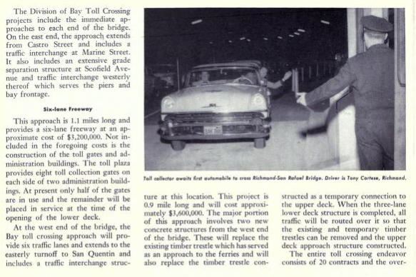
Currently the toll for crossing the Richmond-San Rafael Bridge is $5 dollars for two axle vehicles. West of the tollbooths on Castro Point the official name for the structure the "John F McCarthy Memorial Bridge" can be observed.


Upon landing in Marin County there is a vista point to view the Richmond-San Rafael Bridge at Point San Quentin.

Part 5; a drive on I-80/I-580 on the East Shore Freeway
The freeway between the split in I-80/I-580 in Albany south to the interchange of I-80/I-880/I-580 in Oakland is still known as the East Shore Freeway. Prior to the I-880 and I-580 replacing CA 17 the latter would simply multiplex I-80 en route towards the Richmond-San Rafael Bridge. In early 2020 I found myself on the I-80/I-580 corridor headed south to I-880/Nimitz Freeway after driving Carquinez Scenic Drive.
I-80 westbound Exit 20 is signed as access to I-580 westbound via Fitzgerald Drive. From I-80 west traffic cannot exit onto I-580 westbound to the Richmond-San Rafael Bridge.


I-80 west Exit 19B accesses Hilltop Mall whereas Exit 19A accesses El Portal Drive.


I-80 westbound Exit 18 accesses San Pablo Avenue via Dam Road and in turn San Pablo.


I-80 westbound Exit 17 accesses McBryde Avenue.

I-80 westbound Exit 16 accesses San Pablo Avenue a directly.


I-80 westbound Exit 15 accesses Cutting Boulevard. Cutting Boulevard presently is part of the north terminus of CA 123 which is comprised of mostly of former US 40 on San Pablo Avenue.


I-80 westbound Exit 14A accesses Central Avenue whereas Exit 14B accesses Carison Boulevard.


I-80 westbound merges over I-580 eastbound onto a wrong-way multiplex. I-80 west Exit 13 accesses Cleveland Avenue in Albany.


I-80 west/I-580 east Exit 12 accesses Gilman Street.

I-80 west/I-580 east accesses University Avenue in Berkeley.


CA 13 on Ashby Avenue is accesses via I-80 west/I-580 east Exit 10.


Central Valley traffic is directed to follow I-580 eastbound onto the MacArthur Freeway. Oakland International Airport traffic is directed to I-880 southbound.


I-80 west/I-580 east crosses under numerous digital highway shields approaching Exit 9 for Powell Street in Emeryville.


I-80 westbound splits from I-580 eastbound towards San Francisco and the Bay Bridge at an interchange in Oakland. I-80 westbound traffic splits into the right lanes whereas I-580 eastbound and I-880/Nimitz Freeway traffic southbound follows the left lanes.


Part 6; I-880 south on the Nimitz Freeway from I-80/I-580 to I-238
Following completing the segment of I-80/I-580 in Part 5 I transitioned onto I-880 southbound on the Nimitz Freeway. I-880 southbound Exit 44 in Oakland accesses West Grand Avenue and 7th Street.


I-880 southbound is signed as a Safety Corridor that is mutually shared with I-80 and I-580.


At I-880 Exit 42 there is access to Broadway into downtown Oakland along with unsigned CA 261 (amusingly signed as CA 61) through the Posey Tubes to Alameda.


I-880 southbound passes through downtown Oakland. I-880 south doesn't access I-980 but passes under it's transition ramps. At I-880 southbound Exit 40 there is accesses to 16th Avenue.


I-880 south Exit 39B accesses 23rd Avenue whereas Exit 39A accesses Fruitvale Avenue .


I-880 Exit 38 accesses CA 77 on 42nd Avenue and High Street.

I-880 south Exit 37 accesses 66th Avenue and Zhone Way.


The unfinished Express Lanes on I-880 south become apparent approaching Exit 36 for Hagenberger Road.


I-880 south Exit 35 accesses 98th Avenue.


I-880 south enters the City of San Leandro. I-880 south Exit 34 accesses unsigned CA 112 on Davis Street.


I-880 south Exit 33A and Exit 33B both access Marina Boulevard.


I-880 southbound Exit 31 accesses I-238 eastbound. I-238 east connects to I-580 and is the defacto signed truck route bypass of I-580 on the MacArthur Freeway.


Part 7; the importance of I-880 on the Nimitz Freeway as a truck route
As stated above I-880 on the Nimitz Freeway serves as a truck route bypass of I-580 on the MacArthur Freeway from downtown Oakland east to I-238 in Castro Valley. This truck bypass keeps commercial traffic and hazardous loads off I-580/MacArthur Freeway which allows it to function as a commuter route. Signage reflects trucks being routed to I-880/Nimitz Freeway instead of I-580/MacArthur Freeway such as from I-80 east descending the Bay Bridge in Oakland below.

Likewise I-580 westbound traffic is directed to use I-238 westbound and I-880 northbound on the Nimitz Freeway. This sign assembly can be seen directing truck traffic onto I-238 west and I-880 north along I-580 westbound in Castro Valley.


Part 1; a drive on CA 17
CA 17 is 27 mile State Highway from CA 1 in Santa Cruz north to the junction of I-280/I-880 in San Jose. CA 17 is a heavily trafficked highway with approximately 54,000 to 197,000 vehicles a day in the 1990s according to CAhighways.org. CA 17 was once a far larger route previously which traversed the corridors now occupied by I-880, I-80, and I-580 to reach US 101 in San Rafael. CA 17 even had an unbuilt segment that could have reached the outskirts of Point Reyes. CA 17 is somewhat infamous due to it's current haggard expressway design in the Santa Cruz Range which begins north of CA 1.

From CA 1 I jumped onto CA 17 north which still has Oakland as a control city 75 miles northward.


Unfortunately I was on a time limit and the lighting conditions weren't the best for my camera in the Santa Cruz Range. After a very brief freeway section north of Santa Cruz CA 17 drops to a divided expressway with at-grade intersections. Santas Village Road actually went to a theme park of the same name in Scott's Valley which apparently had opened in 1958 which has since closed.


CA 17 is known for sharp curves in the Santa Cruz Range. The speed limit is posted at 50 MPH and 35 MPH for trucks. There are several large advisory speed signs which are no doubt in place where drivers have hit the center divider. The southern terminus of CA 35 is at an overpass junction on Summit Road but my photos were too blurred up to capture a clear image.


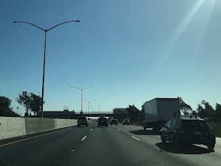
At Bear Creek Road most of the at-grade junctions disappear and CA 17 begins to drop towards Los Gatos and San Jose. The yellow lights are apparently for Cats Restaurant which had been a source of traffic control issues. My understanding is that the high accident rate out of Cats forced Caltrans to route traffic leaving to head southbound to Bear Creek Road. Cats is the location where the 35 MPH truck speed limit ends.


In Los Gatos CA 17 junctions CA 9 which is on Saratoga-Los Gatos Road.


In north Los Gatos CA 17 junctions the CA 85 freeway. There are actually several 511 travel time signs but this was only one I caught a clear picture of.


CA 17 northbound passes through Campbell before terminating at I-280/I-880 in San Jose. I didn't notice any "END" placards at the end of CA 17 but the old button-copy Interstate shields on the guide signs were a nice throwback. The path of travel north on CA 17 continues onto I-880 on the Nimitz Freeway.


Part 2; the history of CA 17 and it's breaking apart into Interstate segments
Today the most exciting thing about CA 17 is the Santa Cruz Range expressway segment. As noted CA 17 used to be far more grand in scope before the advent of the Interstate era as mentioned in the intro. Originally CA 17 was signed as CA 13 back in 1934 but was likely changed to CA 17 by 1936. CA 13 can be seen announced as a new State Highway aligned between Santa Cruz north to San Rafael in an August 1934 Department of Public Works Publication.
CA 13 replaced US 101E north of San Jose (which in turn replaced US 48 between San Jose and Hayward) as it last appears on the 1934 Division of Highway State Map. CA 13 may have been replaced with CA 17 due to the former number being unpopular due to the possible association with bad luck.
1934 State Highway Map City Insert


Conjecture has it that CA 13 would have followed LRN 69 through Alameda and the Posey Tube to downtown Oakland. CA 17 may have been intended to be a new Sign State Route that would have been aligned completely on LRN 105. The numbering of CA 13 as stated above seems to have had caused some controversy which may have led to it being replaced by CA 17. The 1935 Gousha Highway Map of California lends some evidence to this theory and seems to show CA 17 aligned on LRN 69 through Alameda. Interestingly US 101A is shown being routed on LRN 69 and LRN 105 from Oakland south to San Jose.

Part 2A; the early alignment of CA 17
The alignment of CA 17 between Santa Cruz and San Jose was part of Legislative Route 5 which was adopted as part of the 1909 First State Highway Bond Act. CA 17 from San Rafael to Point San Quentin was added to the State Highway System as part of LRN 69 in 1925. LRN 69 was expanded to include a segment between Richmond and San Jose in 1933. That said, the original definition of CA 13 and by extension of CA 17 had it aligned on LRN 69 from Richmond to Oakland, LRN 105 (adopted in 1933 as a State Highway between Half Moon Bay and Oakland according to CAhighways) from Oakland to San Leandro, and LRN 69 from San Leandro to San Jose. CAhighways.org details the history of CA 13/CA 17 and the previous alignment of the Santa Cruz Range in Santa Clara County before the modern expressway built.
The 1935 Division of Highways Maps of the Bay Area Counties provide insight into the original alignment of CA 17. Much of the original CA 17 alignment is still used today as local roads in Santa Cruz County. North of Santa Cruz the alignment on the 1935 Santa Cruz County Map shows CA 17 on; Market Street, Branciforte Drive, Granite Creek Road, and Glenwood Drive to the Santa Clara County Line. The above alignment can be viewed on the 1935 Division of Highways Map.
1935 Santa Cruz County Highway Map

Within Santa Clara County the alignment of CA 17 north of Los Gatos to San Jose followed; Main Street, Los Gatos Boulevard, Bascom Avenue, San Carlos Street, and likely Race Street to US 101 which would have been at the cross street of The Alameda and Santa Clara Street. From US 101 the alignment or early CA 17 split north via 13th Street. CA 17 followed 13th Street northward to Oakland Road and Main Street in Milpitas. From Milpitas CA 17 northbound followed Main Street to Warm Springs Road (which used to connect directly) and Alameda County Line. The alignment of CA 17 within Santa Clara County can be viewed below on the 1935 Division of Highways Map.
1935 Santa Clara County Highway Map

Within Alameda County the original surface alignment of CA 17 followed Warm Springs Boulevard to Warm Springs. Within Warm Springs CA 17 would have turned on what is now Warm Springs Court, Lopes Court, Old Warm Springs Road to Fremont Boulevard. CA 17 northbound followed Fremont Boulevard through Irvington to the City of Fremont. CA 17 north continued on Fremont Boulevard to Alvarado where it turned onto what is now Hesperian Boulevard. CA 17 northbound followed Hesperian Boulevard through Mount Eden to San Lorenzo. Within San Lorenzo CA 17 northbound turned onto Lewelling Boulevard to Washington Avenue. CA 17 northbound followed Washington Avenue into downtown San Leandro where it turned onto 14th Street.
From Hayward CA 17 northbound followed 14th Street as it became International Boulevard in Oakland. Within Oakland CA 17 northbound followed International Boulevard to 44th Avenue. From 44th Avenue CA 17 northbound made a quick transition onto 12th Street. Approaching downtown Oakland CA 17 northbound transitioned from 12th Street on to 8th Street. CA 17 northbound likely followed 8th Street to a jog on Fallon Street to 7th Street where it probably turned toward onto Broadway. CA 17 likely had an original signed terminus at Oakland City Hall where it would have met US 40 at San Pablo Avenue.
The construction of the Bay Bridge led to some changes in the State Highways within Oakland but much of the original alignment of CA 17, LRN 69, and LRN 105 can be viewed on the 1935 Division of Highways Maps below:
1935 Division of Highways Map of Alameda County

Note; the 1935 Division of Highways Map of Oakland below shows the routing of CA 17 extended to the Bay Bridge approach where it met US 40/US 50. The new approach for CA 17 was on LRN 105 on 7th Street west of Broadway and LRN 69 on Cypress Street to US 40/US 50.
1935 Division of Highways Map of Oakland

Despite the initial legislative definition of CA 13 having a terminus in San Rafael it doesn't appear that early CA 17 existed on local roadways in Contra Costa County nor on LRN 69 in Marin County. LRN 69 was connected to Contra Costa County via the Richmond-San Rafael Ferry which operated from Point San Quentin and Castro Point. LRN 69 in Marin County appears to have connected from Point San Quentin west to US 101 via Francisco Boulevard which can be seen on the 1935 Division of Highways Map.

Part 2B; modernizing CA 17/LRN 5 over the Santa Cruz Mountains
Much of CA 17/LRN 5 is shown to be moved to a modernized grade within the Santa Cruz County portion of the Santa Cruz Mountains on the April 1937 California Highways and Public Works Guide.


Open Bids for completing the remaining segment of CA 17/LRN 5 over Santa Cruz Mountains from Oaks Road to Los Gatos were announced in the November 1937 California Highways and Public Works Guide. The article contains the proposed new alignment of CA 17/LRN 5 over the crest of the Santa Cruz Mountains to Los Gatos.


Grading of the final portion of the modern route of CA 17/LRN 5 is discussed in the June 1938 California Highways and Public Works Guide. The original grade of LRN 5 over the Santa Cruz Mountains is cited to have been completed by 1911 with paving beginning in 1921.


The 1938 Division of Highways Map is the first to display CA 17 and the Sign State Routes.
1938 Division of Highways Map

The final leg of the new Los Gatos-Santa Cruz alignment of CA 17/LRN 5 is shown to be complete in the July 1939 California Highways and Public Works Guide.


Part 2C; the evolution of the East Shore Freeway into the Nimitz Freeway
Construction of the East Shore Freeway south of the Bay Bridge began in 1946 with the purpose of replacing much of the surface alignment of CA 17. The new route of LRN 69 and the East Shore Freeway first appears on the 1948 Division of Highways State Map City Insert of Oakland.

The planning stages of the East Shore Freeway are discussed in the January/February 1946 California Highways and Public Works Guide. The East Shore Freeway is described as being planned in 1940 and would incorporate part of Bay Bridge approach of US 40. The route of the East Shore Freeway was planned in overall scope as a new alignment between Richmond and San Jose. Initially budgeted for 1941-1943 delays in the East Shore Freeway project were borne from the United States entering World War II. The East Shore Freeway south of the Bay Bridge is described to be in the planning phases with the first part of the anticipated project being planned from the Oakland City Limit to Oak Street.


The opening the initial phase of the East Shore Freeway in Oakland is described in the July/August 1946 California Highways and Public Works Guide.


The first segment of CA 17/LRN 69 on the East Shore Freeway opened on July 22, 1949 between Oak Street in downtown Oakland and 23rd Avenue. This new segment of the East Shore Freeway first appears on the 1950 Division of Highways State Map City Insert of Oakland.
The opening ceremony of the East Shore Freeway between Oak Street and 23rd Avenue is covered in the July/August 1949 California Highways and Public Works Guide.


By June 1, 1950 the East Shore Freeway was extended to 98th Street and first appears on the 1951 Division of Highways State Map City Insert of Oakland.

The East Shore Freeway is described as being nearly complete to 98th Street in the March/April 1950 California Highways and Public Works Guide.


On June 13, 1952 the East Shore Freeway was extended to Lewelling Boulevard in San Lorenzo and can be seen on the 1953 Division of Highways State Map City Insert. Note; much of Washington Avenue in San Leandro appears to be deleted from the State Highway System by 1953.

The East Shore Freeway reaching San Lorenzo is covered in the May/June 1952 California Highways and Public Works Guide.


On June 5, 1953 the East Shore Freeway was extended to Legislative Route 105 on Jackson Street (future CA 92) in Hayward which can be seen on the 1954 Division of Highways State Map.

The opening of the East Shore Freeway to Jackson Street is covered in the July/August 1953 California Highways and Public Works Guide.
By July 2, 1954 the East Shore Freeway opened north of US 101 on a bypass of Milpitas to Warm Springs. This new segment of CA 17/CA 9 on the East Shore Freeway can be seen on the 1955 Division of Highways State Map.

On June 11, 1957 the Cypress Street Viaduct connected the East Shore Freeway to the Bay Bridge on a limited access grade. On November 14, 1957 the East Shore Freeway was extended to Beard Road near Fremont. These new additions to the East Shore Freeway can be seen on the 1958 Division of Highways State Map.

The prospects of a freeway alignment of CA 17 between Los Gatos and Santa Cruz are described in the March/April 1958 California Highways and Public Works Guide. A bypass of the Los Gatos business district on a 2.1 mile freeway alignment of CA 17 is described as opening in 1957.

On November 24, 1958 the gap in the East Shore Freeway between Alvarado and Warm Springs opened to traffic. Thusly, traffic on CA 17 between San Jose and Oakland could travel on a limited access freeway for the first time. The East Shore Freeway would soon be renamed the Nimitz Freeway in honor of World War II Fleet Admiral Chester W. Nimitz. The completed Nimitz Freeway between San Jose and Oakland can be seen on the 1959 Division of Highways State Map.

The final leg of the East Shore Freeway between El Cerrito and San Jose is cited to have an anticipated completion of late 1958 or early 1959 in the March/April 1958 California Highways and Public Works Guide.
The final gap in the East Shore Freeway (referred to for the first time as the Nimitz Freeway) is cited to be completed between Alvarado and Warm Springs in the November/December 1958 California Highways and Public Works Guide.

The freeway grade of CA 17 between San Jose and Los Gatos opened fully on June 21, 1960 according to the July/August 1960 California Highways and Public Works Guide.


Part 2D; the Richmond-San Rafael Bridge
On September 1, 1956 The Richmond-San Rafael Bridge was opened to traffic which replaced the ferry route between Point San Quentin and Castro Point. On the 1957 Division of Highways State Map LRN 69 is shown to be extended to the Richmond-San Rafael Bridge. By 1960 state maintenance of the Richmond-San Rafael Bridge is shown along with CA 17 extended to US 101 in San Rafael. CA 17 initially utilized a surface routing through Richmond via Hoffman Boulevard and Cutting Boulevard to reach the Richmond-San Rafael Bridge.
1957 Division of Highways Map

1960 Division of Highways Map

The opening the Richmond-San Rafael Bridge is covered in the September/October 1956 California Highways and Public Works Guide.


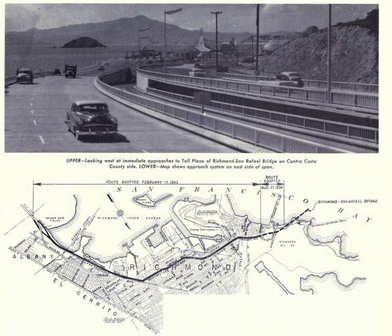


The route of CA 17 is stated to be extended over the Richmond-San Rafael Bridge to US 101 in 1957 according to the March/April 1957 California Highways and Public Works Guide. Funding to build CA 17 from the western approach of the Richmond-San Rafael Bridge as a freeway to US 101 are cited as being ear marked for the 1958-59 fiscal years.

Part 2E; the final evolution of CA 17 and the advent of Interstate 880/Interstate 580
Initially the CA 17 designation survived the 1964 renumbering intact north of San Jose and had a proposed extension northwest to near Point Reyes Station via the corridor of Sir Francis Drake Boulevard to a proposed extension of CA 37. The unbuilt segment of CA 17 towards Point Reyes Station was brought into the State Highway System as a 1959 extension of LRN 69. Note; former surface segments of CA 17 became CA 185 and CA 262 immediately after the 1964 State Highway Renumbering. I-680 was put on a temporary multiplex of CA 17 on the Nimitz Freeway between Warm Springs and San Jose. CA 17 was also assigned as the temporary legislative route on it's former surface segment between Warm Springs and San Jose.
1964 Division of Highways Map

On the 1965 Division of Highways Map CA 238 is shown signed on former CA 17 between Warm Springs and San Jose along with it being refined as part of Legislative Route 680.

The 1975 Caltrans State Highway Map is the first edition to shown I-680 moved off of CA 17 and the Nimitz Freeway to it's own grade between Warm Springs south to San Jose.

In 1981 CA 17 between San Jose and Oakland was transferred to I-880 according to CAhighways. In 1984 CA 17 between Oakland and San Rafael was transferred to I-580 which apparently was proposed in 1983 as I-180 according to CAhighways. Due to new Interstate designations CA 251 replaced unbuilt CA 17 between US 101 and planned CA 37 near Point Reyes Station. All these changes appear for the first time on the 1986 Caltrans State Map.
1986 Caltrans State Map


Interestingly former CA 17 between I-80 and US 101 was transferred to I-580 prior to a new freeway grade being built through Richmond. This can be seen on the City Insert of the 1986 Caltrans State Highway Map where the route of I-580 is shown as an expressway with a planned freeway route.

The John T. Knox Freeway alignment of I-580 through Richmond began construction in 1987 and was completed by 1991. The John T. Knox Freeway is shown nearly completed on the 1990 Caltrans State Highway Map City Insert.

During the October 17, 1989 Loma Prieta Earthquake the Cypress Street Viaduct collapsed which resulted in 42 deaths. In interim traffic headed to I-880 southbound on the Nimitz Freeway was required to detour onto I-980. The gap in I-880 over what had been the Cypress Street Viaduct reopened in July 1997 but it wouldn't repairs wouldn't be completed until 2001. The photo below shows the collapsed Cypress Street Viaduct after the 1989 Loma Prieta Earthquake.

Part 3; exploring the early north terminus of LRN 105 (and likely CA 17) in downtown Oakland
In early 2019 I visited the original west terminus of US Route 40 in what is now Frank Ogawa Plaza in downtown Oakland. Originally US 40 had terminated on San Pablo Avenue at the intersection of 14th Street and Broadway. In 1933 the Legislature allowed the Division of Highways to maintain roadways in cities which resulted in a glut of new routes being adopted. As noted above LRN 105 was one of the many route adoptions of 1933 and it had an original north terminus in downtown Oakland via Broadway at the intersection of US 40/San Pablo Avenue and 14th Street. Early major roadways in Oakland can be observed on the 1934 Division of Highways State Map City Insert.

Note; US 101E likely entered Oakland from the ferry docks on San Francisco Bay. US 101E was likely signed on 7th Street and Broadway where it would have met US 40 at San Pablo Avenue. This rough alignment can be seen in the 1934 City Insert above. Given the Sign State Routes were announced in the August 1934 California Highways and Public Works guide it is likely that the north terminus of CA 13 (and by proxy CA 17) was intended to terminate at Broadway at US 40 in downtown Oakland. It is highly likely CA 13 nor CA 17 were never actually field signed to US 40 in downtown Oakland. LRN 105 on Broadway is shown to no longer be under State Maintenance on Broadway on the 1935 Division of Highways Map of Oakland (seen in Part 2). Ultimately CA 17/LRN 105 would be realigned to US 40/US 50 approaching the Bay Bridge via 7th Street and Cypress Street which is made first clear on the 1938 Division of Highways State Map City Insert. For reference the Bay Bridge opened in November of 1936.

Back in 2019 my approach to the original terminus of LRN 105/CA 17 was on former US 40/San Pablo Avenue. Between 16th and 14th Streets the route of US 40/San Pablo Avenue is now Frank Ogawa Plaza.


Continuing south to what was the corner of San Pablo Avenue, 14th Street and Broadway there is no real indication that US 40, US 101E, or even CA 17 were once present.


San Pablo Avenue doesn't even get a mention on the street blades located at Broadway and 14th Street. CA 17/LRN 105 southbound would have split right from US 40/San Pablo Avenue on Broadway.

From what was the terminus of US 40 and CA 17 the 320 foot Oakland City Hall is obvious. Oakland City Hall was completed in 1914 and was at the time the tallest building on the West Coast. Oakland City Hall was meant to resemble New York City high rises and used to feature a 12th floor jail complete without out yard (talk about a jail with a view). Oakland City Hall was added to the National Register of Historic Places in 1983 but the structure was damaged in the 1989 Loma Prieta Earthquake. Since the Loma Prieta Earthquake Oakland City Hall has been retrofitted.


Part 4; a drive on the Richmond-San Rafael Bridge
In late 2017 I found myself on I-580 westbound headed to the Marin Headlands over the Richmond-San Rafael Bridge. The Richmond-San Rafael Bridge is a double deck truss bridge spanning 5.5 miles with a maximum clearance of 185 feet. The top deck of the Richmond-San Rafael Bridge carries westbound I-580 and the lower deck carries the eastbound lanes.
Currently the toll for crossing the Richmond-San Rafael Bridge is $5 dollars for two axle vehicles. West of the tollbooths on Castro Point the official name for the structure the "John F McCarthy Memorial Bridge" can be observed.

The double decker structure of the Richmond-San Rafael Bridge is pretty striking to behold. The right hand shoulder on both decks is wide enough to add a third lane of vehicle capacity. The lower deck shoulder is used presently used as a breakdown lane whereas the top deck was opened as a Bike and Pedestrian Path in November of 2019. The new Bike and Pedestrian Path on the Richmond-San Rafael Bridge makes it the second structure over San Francisco Bay to facilitate non-motorized traffic after the Golden Gate Bridge.


Upon landing in Marin County there is a vista point to view the Richmond-San Rafael Bridge at Point San Quentin.

Part 5; a drive on I-80/I-580 on the East Shore Freeway
The freeway between the split in I-80/I-580 in Albany south to the interchange of I-80/I-880/I-580 in Oakland is still known as the East Shore Freeway. Prior to the I-880 and I-580 replacing CA 17 the latter would simply multiplex I-80 en route towards the Richmond-San Rafael Bridge. In early 2020 I found myself on the I-80/I-580 corridor headed south to I-880/Nimitz Freeway after driving Carquinez Scenic Drive.
I-80 westbound Exit 20 is signed as access to I-580 westbound via Fitzgerald Drive. From I-80 west traffic cannot exit onto I-580 westbound to the Richmond-San Rafael Bridge.


I-80 west Exit 19B accesses Hilltop Mall whereas Exit 19A accesses El Portal Drive.


I-80 westbound Exit 18 accesses San Pablo Avenue via Dam Road and in turn San Pablo.


I-80 westbound Exit 17 accesses McBryde Avenue.

I-80 westbound Exit 16 accesses San Pablo Avenue a directly.


I-80 westbound Exit 15 accesses Cutting Boulevard. Cutting Boulevard presently is part of the north terminus of CA 123 which is comprised of mostly of former US 40 on San Pablo Avenue.

I-80 westbound Exit 14A accesses Central Avenue whereas Exit 14B accesses Carison Boulevard.


I-80 westbound merges over I-580 eastbound onto a wrong-way multiplex. I-80 west Exit 13 accesses Cleveland Avenue in Albany.


I-80 west/I-580 east Exit 12 accesses Gilman Street.

I-80 west/I-580 east accesses University Avenue in Berkeley.


CA 13 on Ashby Avenue is accesses via I-80 west/I-580 east Exit 10.


Central Valley traffic is directed to follow I-580 eastbound onto the MacArthur Freeway. Oakland International Airport traffic is directed to I-880 southbound.


I-80 west/I-580 east crosses under numerous digital highway shields approaching Exit 9 for Powell Street in Emeryville.


I-80 westbound splits from I-580 eastbound towards San Francisco and the Bay Bridge at an interchange in Oakland. I-80 westbound traffic splits into the right lanes whereas I-580 eastbound and I-880/Nimitz Freeway traffic southbound follows the left lanes.


Part 6; I-880 south on the Nimitz Freeway from I-80/I-580 to I-238
Following completing the segment of I-80/I-580 in Part 5 I transitioned onto I-880 southbound on the Nimitz Freeway. I-880 southbound Exit 44 in Oakland accesses West Grand Avenue and 7th Street.


I-880 southbound is signed as a Safety Corridor that is mutually shared with I-80 and I-580.


At I-880 Exit 42 there is access to Broadway into downtown Oakland along with unsigned CA 261 (amusingly signed as CA 61) through the Posey Tubes to Alameda.


I-880 southbound passes through downtown Oakland. I-880 south doesn't access I-980 but passes under it's transition ramps. At I-880 southbound Exit 40 there is accesses to 16th Avenue.


I-880 south Exit 39B accesses 23rd Avenue whereas Exit 39A accesses Fruitvale Avenue .


I-880 Exit 38 accesses CA 77 on 42nd Avenue and High Street.

I-880 south Exit 37 accesses 66th Avenue and Zhone Way.


The unfinished Express Lanes on I-880 south become apparent approaching Exit 36 for Hagenberger Road.


I-880 south Exit 35 accesses 98th Avenue.


I-880 south enters the City of San Leandro. I-880 south Exit 34 accesses unsigned CA 112 on Davis Street.


I-880 south Exit 33A and Exit 33B both access Marina Boulevard.


I-880 southbound Exit 31 accesses I-238 eastbound. I-238 east connects to I-580 and is the defacto signed truck route bypass of I-580 on the MacArthur Freeway.


Part 7; the importance of I-880 on the Nimitz Freeway as a truck route
As stated above I-880 on the Nimitz Freeway serves as a truck route bypass of I-580 on the MacArthur Freeway from downtown Oakland east to I-238 in Castro Valley. This truck bypass keeps commercial traffic and hazardous loads off I-580/MacArthur Freeway which allows it to function as a commuter route. Signage reflects trucks being routed to I-880/Nimitz Freeway instead of I-580/MacArthur Freeway such as from I-80 east descending the Bay Bridge in Oakland below.

Likewise I-580 westbound traffic is directed to use I-238 westbound and I-880 northbound on the Nimitz Freeway. This sign assembly can be seen directing truck traffic onto I-238 west and I-880 north along I-580 westbound in Castro Valley.

Comments