Upon my arrival in downtown Seattle after taking the Bremerton-Seattle Ferry across Puget Sound I stopped to see the soon to be razed Alaskan Way Viaduct. The Alaskan Way Viaduct is an elevated freeway and a former segment of US Route 99. Interestingly US 99 is still signed at the southbound Viaduct Ramp located at Columbia Street and 1st Avenue in Pioneer Square.
This blog entry is the second in a series of two related to transportation in Seattle related to the Alaskan Way Viaduct. The first entry in the series can be found here:
Alaskan Way Viaduct Legacy Part 1; Alki Point, Duwamish Head and Railroad Avenue
Alaskan Way Viaduct Legacy Part 1; Alki Point, Duwamish Head and Railroad Avenue
This blog is part of the larger Gribblenation US Route 99 Page. For more information pertaining to the other various segments of US Route 99 and it's three-digit child routes check out the link the below.

Alaskan Way Viaduct Legacy Part 2
- Marginal Way
- Possibly a eastern jog Holgate Street
- 4th Avenue
- Possibly Stewart Street
- West Lake Avenue
While US 99 isn't displayed on the city insert of the 1930 map below the through route Seattle is still shown following the rough alignment noted above through downtown.
1930 Washington State Highway Map
By the late 1920s there was some apparent plans to build an elevated roadway roughly in the location of the current Alaskan Way Viaduct. The article below from Historylink.org notes that the proposed elevated roadway was to route US 99 on a bypass of downtown over Railroad Avenue to north to the Greenwood neighborhood.
Historylink on the Alaskan Way Viaduct Part 1
As noted above on the Historylink article the condition of the wooden pilings on Railroad Avenue were essentially becoming untenable to maintain a through route by the 1930s. The pilings of Railroad Avenue were subject to be being worn down by rising tides of Elliott Bay. The City of Seattle received Federal Funds which it used to build a seawall along Railroad Avenue which was constructed from 1934 to 1935. Upon the completion of a viable seawall, Railroad Avenue was rebuilt as a four-lane roadway which opened as Alaskan Way in 1936.
Following the construction of the Aurora Bridge over Lake Union in 1932 it appears that US 99 through Seattle was somewhat straightened. It appears that US 99 utilized 7th Avenue from Aurora Avenue to reach West Lake Avenue. US 99 continued south to 4th Avenue which continued south through downtown to reach Marginal Way. It appears that Primary State Highway 1K appears to have also been routed on 1st Avenue as an alternate to US 99 (Primary State Highway 1) which was likely in 1937. The alignment through downtown Seattle is shown on a 1940 City Insert of Seattle. It is clear by looking at the 1940 map that Alaskan Way was still not a viable means of bypassing downtown Seattle.
1940 Map of Seattle
The same alignment of US 99 in Seattle described in the above paragraph also appears on the 1944 State Highway Map.
1944 State Highway Map
The following article from Historylink.org details the proposals that eventually led to the Alaskan Way Viaduct. The article is substantially far more detailed that I'm willing to write. Specifically the article goes over several proposals, engineering assessments, concerns of business owners given during public comment and even additional funding efforts.
Historylink.org on the Alaskan Way Viaduct Part 2
In short the design of the Alaskan Way Viaduct was approved in 1947 and sought to utilize money allocated from the 1944 Federal Aid Highway Act. An important change noted in the above article was in early 1949 when the state legislature approved the State Highway Department assuming jurisdiction for US 99 in Seattle which had been previously been maintained by the city.
The actual construction of the Alaskan Way Viaduct began in February of 1950. Although the full scope of the Alaskan Way Viaduct project was not completed by 1953 it did open between Elliott Avenue south to 1st Avenue by April. The Battery Street Subway portion of the Alaskan Way Viaduct project between Elliott Avenue and Aurora Avenue opened in July of 1954. The southern segment of the Alaskan Way Viaduct from 1st Avenue to the Spokane Street Viaduct opened in September of 1959. Again Historylink.org once again has an article far larger in scope that covers pretty much every facet of the entire construction history of the Alaskan Way Viaduct.
Historylink.org on the Alaskan Way Viaduct Part 3
Interestingly the 1956 State Highway Map shows the Alaskan Way Viaduct signed as US Route 99A with a lead-up northward along 1st Avenue while mainline US 99 is still shown in downtown Seattle. The Alaskan Way Viaduct is still shown as US Route 99A with the 4th Avenue surface route shown as the mainline US 99 also on a 1966 map of Seattle.
1956 State Highway Map
1966 Map of Seattle
Edit 05/15/18: I was shown a map scan by Kacie Jane on the AAroads web forum of downtown Seattle in 1957. The 1957 map scan shows a US 99 Bypass routed via 1st Avenue and Railroad Way to the Alaskan Way Viaduct and a US 99 Business routed on 4th Avenue. A link to the 1957 map scan can be found here.
1957 Downtown Map of Seattle
Regarding US 99 versus US 99A, I'm not completely sure if the mainline route was actually ever truly moved out of downtown Seattle onto the Alaskan Way Viaduct. US 99 was decommissioned by most accounts in 1969 which led to the creation of Washington State Route 99. The US 99 shield located at 1st Avenue and Columbia Street seems to suggest that the mainline highway made it onto the Alaskan Way Viaduct at some point before it was decommissioned. Either way, the only way to conclusively prove what was going with US 99 in downtown Seattle would be to obtain some sort of official state highway maps from 1967 through 1970. For what it is worth USends offers information regarding when US 99 was decommissioned.
USends on US 99
Edit 5/13/18: I was shown a map scan from 1969 of downtown Seattle on the AAroads forum by Flickr User Arthur Allen. The map shows US 99 on the Alaskan Way Viaduct, there no alternate or business route through downtown. The 1969 map of Seattle can be viewed here:
Arthur Allen Flickr Page showing 1969 Gousha Map of Seattle
Arthur Allen also shared a map scan of Seattle in 1970 showing US 99 was replaced by WA 99:
Arthur Allen Flickr page showing 1970 map scan of Seattle
The downfall of the Alaskan Way Viaduct is a well known subject. The structure was damaged in the 2001 Nisqually Earthquake which was a magnitude 6.8 tremor. The Nisqually Earthquake substantially damaged the joints and foundations of the Alaskan Way Viaduct leading to extra bracing being installed on remaining sections. A section of the southern Viaduct was demolished in 2011 and boring for a replacement tunnel began in 2013. The new tunnel replacement for the Alaskan Way Viaduct is scheduled to open in 2019 which will lead in to the demolition of the remaining structure. The tunneling project essentially has been a massive nightmare of unforeseen engineering problems and construction cost overruns, again Historylink.org has far more details.
Historylink.org on the Alaskan Way Viaduct Part 4
So with all that in mind my interest in the Alaskan Way Viaduct is that it was in some form or fashion part of US Route 99. For me US Route 99 is probably the most interesting US Route second only to US Route 66. I've actually documented much of US 99 in California; be it the original alignment in Fresno, Bakersfield or even the Ridge Route...suffice to say I was invested in what was going with the Alaskan Way Viaduct. So with that said I felt it was important to document what is not only an important structure in Seattle but also one of the most important north/south highways that ever existed in the United States. So call it personal bias or a guilty pleasure, I wasn't passing up the chance to get photos and document something before the Alaskan Way Viaduct was gone forever.
So with all that in mind the full width of the remaining Alaskan Way Viaduct structure is easily observed from the Bremerton-Seattle Ferry.


The Alaskan Way Viaduct structure is very apparent disembarking the Bremerton-Seattle Ferry.

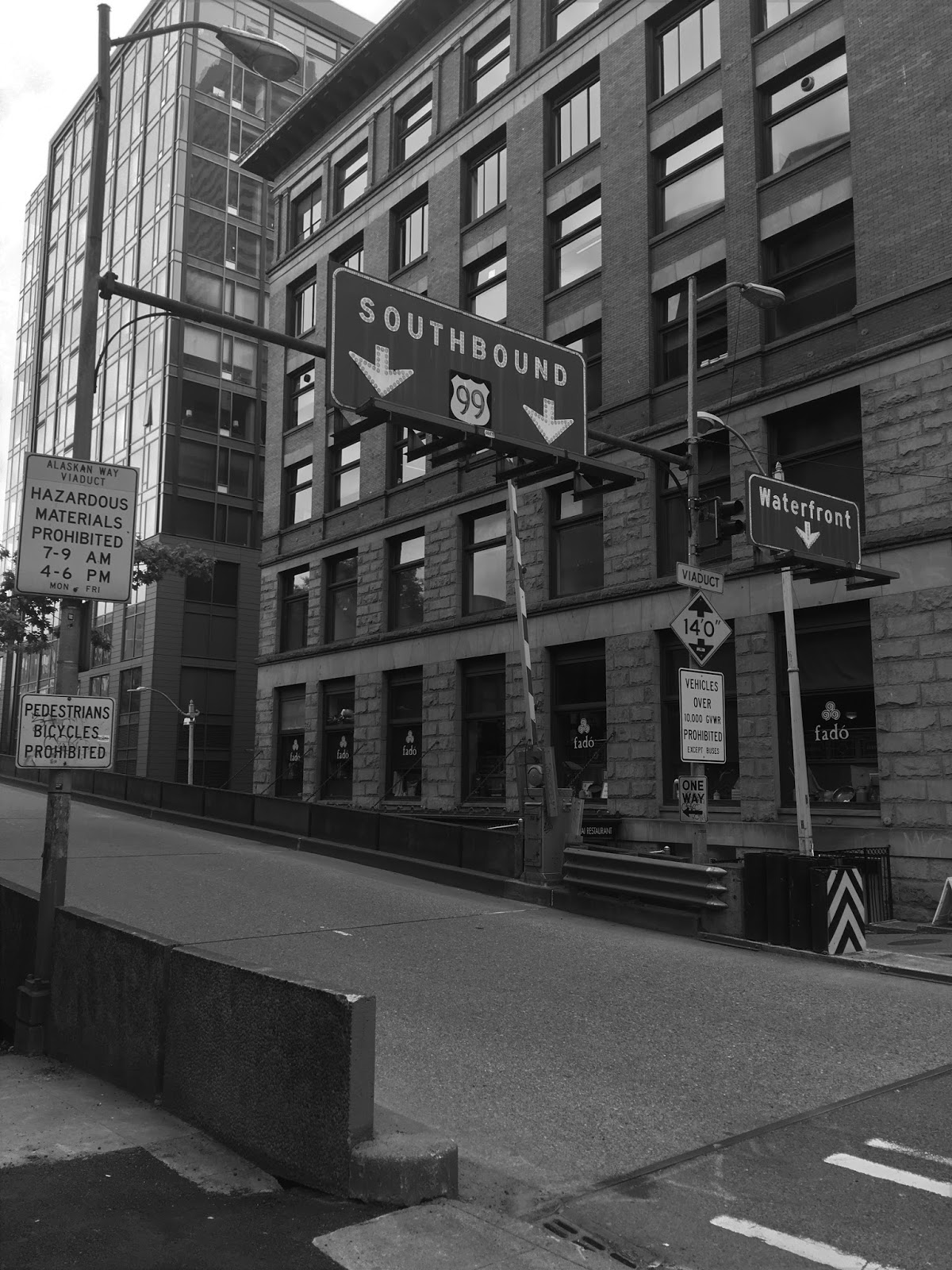
As stated previously my first point of business was to get a photo of the US 99 shield on the southbound ramp on Columbia Street.

The Columbia Street ramp snakes over several city blocks to reach the Alaskan Way Viaduct. I followed the ramp from below on Columbia Street until I reached Alaskan Way.


Along Alaskan Way I took as many photos as possible of the width of the Viaduct Structure. I'm sure that it must have looked odd to people disembarking the ferries to see someone climbing stairs at Coleman Dock to take pictures of a double decker freeway.


I even took some pictures below the substructure of the southbound lanes from Alaskan Way.


I climbed back up to Western Avenue from Union Street. Interestingly the vacant lot provided some scant evidence that not all was what it seemed with the elevated streets east of Alaskan Way, but I'll touch on that when I get to writing about Pioneer Square.

Looking back at the Viaduct from Union Street.

Before climbing back up to 1st Avenue I walked under the northbound Seneca Street exit.

The Viaduct from the Harbor Step.

A couple surface photos of the northbound exit at Seneca Street and 1st Avenue.


I also grabbed some photos of some likely soon to be extinct signs on 1st Avenue directing traffic towards the Viaduct and Alaskan Way.


Interestingly a local shop owner saw me taking photos of the ramp on Seneca Street, he actually told me to get as many photos as I could before the Viaduct was gone. Suffice to say given the general attitude of the local populace towards the Alaskan Way Viaduct I was somewhat surprised that anyone had anything somewhat positive to say.
The Alaskan Way Viaduct is really one of the few remaining freeways of its kind after the demise of elevated structures like the Embarcadero Freeway in San Francisco and Central Artery in Boston. Yes, I can understand how the Alaskan Way Viaduct has become to despised by the local populace in Seattle. The Viaduct was built in an era where infrastructure development was pushed with almost no regard to aesthetics. The design seems to have been not what anyone outside of the early 20th Century would have wanted. The Alaskan Way Tunnel will likely serve the city of Seattle better and liven up the Waterfront area. But if you're a fan of infrastructure or highways and happen to be in Seattle this next year I'd recommend you see the Viaduct before it disappears for good.
Update 5/25/18: I just returned from a second trip to the Seattle Area. While I was in the city, I was able to take some photos of the Alaskan Way Viaduct driving southbound from Valley Street.
Approaching the Battery Street tunnel on southbound WA 99 there is one final opportunity for traffic to exit into downtown onto Denny Way.

Entering the Battery Street Tunnel on southbound WA 99.

As WA 99 exits the Battery Street Tunnel it joins the Alaskan Way Viaduct while it is on a side-by-side configuration.

I took an overview shot of the Battery Street Tunnel exit from 1st Avenue. What can't be seen just ahead is the Southbound exit for Western Avenue.

As WA 99 continues on the Alaskan Way Viaduct along the Seattle Waterfront the southbound lanes descend below the northbound.


There are no exits into downtown from the southbound lanes on WA 99 as it runs on the lower level of the Alaskan Way Viaduct. The next exit is ahead at Royal Brougham Way followed by Atlantic Street.

Ferry Traffic on southbound WA 99 on the Alaskan Way Viaduct is directed to Royal Brougham Way.

Royal Brougham Way also provides access to Safeco Field, CenturyLink Field and Pioneer Square.

As the Alaskan Way Viaduct approaches CenturyLink Field it descends a temporary structure to a dual surface grade, this part of Viaduct is already demolished. From the northbound lanes the new Alaskan Way Tunnel is very evident but the project zone can be see on the second photo below on the right.


Atlantic Street is signed as part of WA 519 which directs ferry traffic from Coleman Dock to I-5 and I-90.

As stated above Railroad Way was used as a temporary access point from 1st Avenue when the first section of the Alaskan Way Viaduct was completed. This photo shows the approach from 1st Avenue and Railroad Way towards the Alaskan Way Viaduct. Traffic on Railroad Way can no longer access the Alaskan Way Viaduct in either travel direction.

I took some photos of the Alaskan Way Seawall from Pier 55. It's hard to imagine a planked Railroad Avenue running on a beachfront where Alaskan Way and the Viaduct now stand.


As a side note US 10 was extended on 4th Avenue from Seattle Boulevard to Battery Street at some point when the Alaskan Way Viaduct and Battery Street Tunnel were completed. The photos provided by Arthur Allen on AAroads show US 10 signed on 4th Avenue along with US 99 Business. The year these photo were taken is uncertain but there appears to be a 1959 Chevrolet Impala in the first one.
4th Avenue Photo 1
4th Avenue Photo 2
This photo from 1940 was provided by Bruce on AAroads. It shows a fatality count for 1939 compared to 1940 for all Seattle City Traffic, This sign was displayed on US 99 along 4th Avenue
1940 4th Avenue Fatality Counter
Comments