After I left Trail Ridge and Rocky Mountain National Park I took US Route 34 to I-25/US 87 north into Wyoming. My road ahead was in Custer in the Black Hills of South Dakota.

This blog is a continuation of Part 2 which covered the Trail Ridge Road of Rocky Mountain National Park.
Part 2; Trail Ridge Road/US Route 34 and Rocky Mountain National Park
I continued north on I-25/US 87 which briefly picked up US 85 in Cheyanne. North of Cheyanne the routing of I-25/US 87 was undergoing heavy construction which had traffic onto the shoulder for a solid 20 miles. Eventually I made it past the construction and pulled off the Interstate onto US 26 in Platte County where I then headed eastbound. My next turn was north on WY 270 so I could check the ghost towns of Hartville, Sunrise and Manville.
Along WY 270 there is a junction for the small 1.1 mile WY 318. WY 318 heads east from WY 270 through Hartville to the former company town of Sunrise. Before the 1970s WY 270 used to terminate at WY 318 while the latter continued south to US 26 near Guernsey. There was a point in time when WY 318 used to cross the Sunrise Mine but it appears to have been realigned due to the open pit mining at some point westward to the present route of WY 270. The alignment in question regarding WY 318 through Sunrise can be seen on the 1951 and 1956 State Highway Maps of Wyoming.
1951 State Highway Map
1956 State Highway Map
Hartville apparently is one of the oldest towns in Wyoming. Hartville and the Sunrise were active mining areas worked from the 1880s up until about 1980. Iron was most common ore mined out of Hartville and Sunrise but I'm to understand that there was some copper claims nearby as well. The earliest reference to Hartville I could find on a map of Wyoming was in 1891.
1891 Sectional Map
In the 1890s the Wyoming Railway and Iron Company built a line from nearby Guernsey to exploit the iron mining claims near Hartville. By the end of the decade the Colorado Fuel and Iron Company began to invest in mining near Hartville which led to the creation of the company town Sunrise in the early 1900s. The Sunrise Mine used various types of mining methods through the years but the town and mine were apparently shuttered in 1980. Today WY 318 dead-ends at a gate preventing access to Sunrise but various buildings can still be seen near the mining facilities from Satellite.
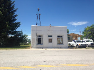
Hartville apparently has about 60 residents left which are mainly congregated to WY 318 on Main Street. There are many early 20th Century style buildings lining Main Street, the former rail grade appears to be on Railroad Street a block north.


After visiting Hartville I continued north on WY 270 to a junction with US 18/20 in Manville located in Niobrara County. Manville apparently has had Post Office Service since 1887 and shows up on the above Wyoming Map from 1891. Apparently Manville used to a population approaching 600 during the 1920s. The community essentially is nothing but a ruin consisting of abandoned buildings along 5th street and derelict roads.


Interestingly 9th Avenue through Manville is a former alignment of US 20. US 18 was apparently extended through Manville to Orin in 1967 from a previous western terminus in Mule Creek Junction at US 85 according to USends.com.
USends.com on US 18
After leaving Manville I continued east on US 18/20 to Lusk where I followed US 18/85 north. Interestingly there was a large bridge detour over the rail lines which involved using Griffith Boulevard.
I followed US 85 north to US 16 as US 18 split east towards the South Dakota State Line. Upon turning east on US 16 I took into to the South Dakota State Line in the Black Hills of Custer County. I did stop at Jewel Cave National Monument to see if there was an open cave tour which was to no avail. I did do some brief hiking in the canyons surrounding the Jewel Cave but neglected to take any photos due to not being able to take a cave tour.
East of the Jewel Cave I made it to my final destination for the day in City of Custer. Custer is the County Seat of Custer County and is generally considered to be the oldest European Community in the Black Hills having been founded in 1875. Gold Claims near Custer were found during the 1874 Black Hills Expedition which was led by Lt. Colonel George Armstrong Custer. The City of Custer was the genesis point of the Black Hills Gold Rush which apparently peaked out around 1877.
The City of Custer has various routes traversing it. US 16A splits away from US 16 in downtown Custer and heads east towards Custer State Park in addition to Mount Rushmore. US 385 heads south towards Wind Cave National Park.

In general most of the historic buildings in Custer are located on Mount Rushmore Road in downtown.


Part 4 of this series can be found here:
2016 Summer Mountain Trip Part 4; Wind Cave National Park

This blog is a continuation of Part 2 which covered the Trail Ridge Road of Rocky Mountain National Park.
Part 2; Trail Ridge Road/US Route 34 and Rocky Mountain National Park
I continued north on I-25/US 87 which briefly picked up US 85 in Cheyanne. North of Cheyanne the routing of I-25/US 87 was undergoing heavy construction which had traffic onto the shoulder for a solid 20 miles. Eventually I made it past the construction and pulled off the Interstate onto US 26 in Platte County where I then headed eastbound. My next turn was north on WY 270 so I could check the ghost towns of Hartville, Sunrise and Manville.
Along WY 270 there is a junction for the small 1.1 mile WY 318. WY 318 heads east from WY 270 through Hartville to the former company town of Sunrise. Before the 1970s WY 270 used to terminate at WY 318 while the latter continued south to US 26 near Guernsey. There was a point in time when WY 318 used to cross the Sunrise Mine but it appears to have been realigned due to the open pit mining at some point westward to the present route of WY 270. The alignment in question regarding WY 318 through Sunrise can be seen on the 1951 and 1956 State Highway Maps of Wyoming.
1951 State Highway Map
1956 State Highway Map
Hartville apparently is one of the oldest towns in Wyoming. Hartville and the Sunrise were active mining areas worked from the 1880s up until about 1980. Iron was most common ore mined out of Hartville and Sunrise but I'm to understand that there was some copper claims nearby as well. The earliest reference to Hartville I could find on a map of Wyoming was in 1891.
1891 Sectional Map
In the 1890s the Wyoming Railway and Iron Company built a line from nearby Guernsey to exploit the iron mining claims near Hartville. By the end of the decade the Colorado Fuel and Iron Company began to invest in mining near Hartville which led to the creation of the company town Sunrise in the early 1900s. The Sunrise Mine used various types of mining methods through the years but the town and mine were apparently shuttered in 1980. Today WY 318 dead-ends at a gate preventing access to Sunrise but various buildings can still be seen near the mining facilities from Satellite.
Hartville apparently has about 60 residents left which are mainly congregated to WY 318 on Main Street. There are many early 20th Century style buildings lining Main Street, the former rail grade appears to be on Railroad Street a block north.


After visiting Hartville I continued north on WY 270 to a junction with US 18/20 in Manville located in Niobrara County. Manville apparently has had Post Office Service since 1887 and shows up on the above Wyoming Map from 1891. Apparently Manville used to a population approaching 600 during the 1920s. The community essentially is nothing but a ruin consisting of abandoned buildings along 5th street and derelict roads.


Interestingly 9th Avenue through Manville is a former alignment of US 20. US 18 was apparently extended through Manville to Orin in 1967 from a previous western terminus in Mule Creek Junction at US 85 according to USends.com.
USends.com on US 18
After leaving Manville I continued east on US 18/20 to Lusk where I followed US 18/85 north. Interestingly there was a large bridge detour over the rail lines which involved using Griffith Boulevard.
I followed US 85 north to US 16 as US 18 split east towards the South Dakota State Line. Upon turning east on US 16 I took into to the South Dakota State Line in the Black Hills of Custer County. I did stop at Jewel Cave National Monument to see if there was an open cave tour which was to no avail. I did do some brief hiking in the canyons surrounding the Jewel Cave but neglected to take any photos due to not being able to take a cave tour.
East of the Jewel Cave I made it to my final destination for the day in City of Custer. Custer is the County Seat of Custer County and is generally considered to be the oldest European Community in the Black Hills having been founded in 1875. Gold Claims near Custer were found during the 1874 Black Hills Expedition which was led by Lt. Colonel George Armstrong Custer. The City of Custer was the genesis point of the Black Hills Gold Rush which apparently peaked out around 1877.
The City of Custer has various routes traversing it. US 16A splits away from US 16 in downtown Custer and heads east towards Custer State Park in addition to Mount Rushmore. US 385 heads south towards Wind Cave National Park.

In general most of the historic buildings in Custer are located on Mount Rushmore Road in downtown.


Part 4 of this series can be found here:
2016 Summer Mountain Trip Part 4; Wind Cave National Park
Comments