
California State Route 207 I & II

On my way home from the the San Francisco Bay Area I took California State Route 152 east over Pacheco Pass to California State Route 33 north towards Santa Nella.  This particular segment of California State Route 33 was once the original California State Route 207.  In this article we examine the history of both iterations of California State Route 207.


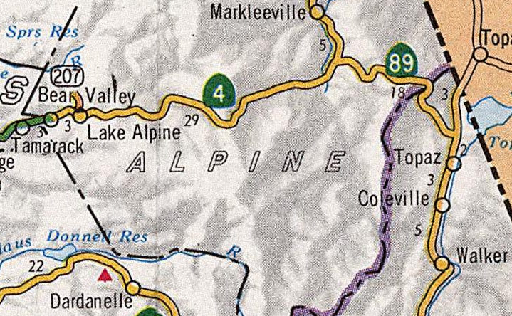
The current California State Route 207 ("CA 207") is a one mile State Highway which connects California State Route 4 near Lake Alpine to the Bear Valley Ski Area.  CA 207 is located within the Sierra Nevada Mountains of Alpine County.  


Part 1; the history of California State Route I

The original CA 207 was created during the 1964 State Highway Renumbering out of Legislative Route 121 ("LRN 121") from CA 152 north to CA 33 in Santa Nella.  The original CA 207 was a short 3 mile highway which was aligned over an important regional connecting corridor.  LRN 121 was added to the State Highway System in 1933 according to CAhighways.org.  The first CA 207 can be seen on the 1964 Division of Highways State Map


According to CAhighways.org the original CA 207 was deleted in 1972 when CA 33 was shifted onto it.  Originally CA 33 was aligned west of Los Banos to Santa Nella by way of Volta.  The new alignment of CA 33 west of Los Banos over the corridor of what was the first CA 207 can be seen on the 1975 Caltrans State Map


Part 2; a drive on what was California State Route I
 
The first CA 207 would have begun at CA 152 and run north from the expressway on Santa Nella Boulevard.


For a 3 mile route the first CA 207 had a lot going on as it would have quickly had a junction with the Medeiros Recreation Area almost immediately north of CA 152.


The first CA 207 would have crossed the O'Neill Forebay followed by Delta Mendota Canal before entering Santa Nella.


The first CA 207 would have terminated at CA 33/Henry Miller Avenue.


Part 3; the history of California State Route 207 II

According to CAhighways.org the second CA 207 was added to the State Highway System as part of 1979 Legislative Chapter 572.  The second CA 207 originally carried a definition of Lake Alpine to the Mount Reba Ski Area.  The second CA 207 first appears on the 1981 Caltrans State Highway Map.  


The Bear Valley Ski Area traces it's history to Harvey Blood's Toll Station on the Ebbetts Pass Road which became a tolled facility in the early 1860s.  The first written documentation referring to the area as "Bear Valley" is first cited in 1869 according to bearvalley.com.  In 1910 the Ebbetts Pass Toll Road was made a free highway as it was added to the State Highway System as Legislative Route 24 as part of the 1909 First State Highway Bond Act.  Blood's Station continued to operate until 1920 when it was sold to the Bishop Mining and Cattle Company.  

In 1952 the Orvis Family purchased 480 acres of land from the Bishop Mining and Cattle Company.  The Orvis Family later purchased 400 additional acres of Stanislaus National Forest parcels north of Bear Valley towards Mount Reba in 1963 with the intentions of building a ski resort.  The Mount Reba Ski Area opened in 1967 (along with what would become CA 207 II) for the winter ski season.  In June of 1991 the Mount Reba Ski Area was purchased and renamed to the Bear Valley Ski Area.


Part 4; a drive on California State Route 207 II

CA 4 eastbound intersects modern CA 207 at Postmile ALP R2.906.  CA 4 eastbound has two reassurance shields for CA 207 mounted above light posts approaching the actual junction.  


The 24% gradient warning for CA 4 eastbound over Ebbetts Pass can be found at the junction with modern CA 207.  The 24% grades ahead mostly apply in reality to Pacific Grade Summit but nonetheless are very real. 

Modern CA 207 travels northwest from CA 207 and has at least one reassurance shield.  Modern CA 207 is known as "Mount Reba Road" and State Maintenance ends at Postmile ALP 1.36.  CA 207 ends within view of Mount Reba.  


Comments

Popular posts from this blog

Old River Lock & Control Structure (Lettsworth, LA)

  The Old River Control Structure (ORCS) and its connecting satellite facilities combine to form one of the most impressive flood control complexes in North America. Located along the west bank of the Mississippi River near the confluence with the Red River and Atchafalaya River nearby, this structure system was fundamentally made possible by the Flood Control Act of 1928 that was passed by the United States Congress in the aftermath of the Great Mississippi River Flood of 1927 however a second, less obvious motivation influenced the construction here. The Mississippi River’s channel has gradually elongated and meandered in the area over the centuries, creating new oxbows and sandbars that made navigation of the river challenging and time-consuming through the steamboat era of the 1800s. This treacherous area of the river known as “Turnbull’s Bend” was where the mouth of the Red River was located that the upriver end of the bend and the Atchafalaya River, then effectively an outflow

Interstate 10S and the original Interstate 110 in California

Interstate 10S is a short spur of Interstate 10 along San Bernardino Freeway in downtown Los Angeles.  Interstate 10S begins at the Santa Ana Freeway (US Route 101) and extends east to Interstate 5 where it merges into mainline Interstate 10.  Interstate 10S is one of the oldest freeway segments in Los Angeles having been part of US Routes 60, 70 and 99 when it was part of the corridor of the Ramona Expressway.  The current corridor of Interstate 10S was assigned as Chargeable Corridor H following the passage of the 1956 Federal Highway Aid Act.  Interstate 110 was a short-lived designation which comprised the segment San Bernardino Freeway from US Route 101 to Interstate 5 between 1964-1968.  The original Interstate 110 was dropped as a Chargeable Corridor during 1965 and consolidated as Interstate 10S during 1968.   The original Interstate 110 can be seen as the blog cover photo as it was featured on the 1964 Division of Highways Map.  Below the entire 0.65-mile length of Interstate

Vicksburg Bridge (Vicksburg, MS)

  Located a few hundred feet downriver from the Old Vicksburg Bridge, the Vicksburg Bridge, or the “New” Bridge, serves as the city’s vehicular crossing of the Mississippi River on the main highway connecting Vicksburg with northeastern Louisiana to the west and the state capital of Jackson to the east. The completion of the original Vicksburg Bridge in 1930 was seen as a huge success and the bridge proved to be a profitable entity for both road and railroad interests along the path of the Dixie Overland Highway and the subsequent US Highway 80 corridor. In the years after the creation of the National Interstate Highway System, planning commenced on a new bridge at the site that would relieve the congestion on the existing bridge while providing for a more modern crossing of the river that would be safe for all vehicles. The construction of the new bridge at Vicksburg was completed in 1973 and its design intentionally mimics that of its predecessor nearby. This was due in large part