After completing Valley of Fire Highway I found myself at Northshore Road near the southern terminus of Nevada State Route 169 in the Lake Mead National Recreation Area. The junction with Old St. Thomas Road was located nearby which was part of NV 12. I wasn't certain about the road conditions on Old St. Thomas Road but figured that I would try it one way or another.

All of current NV 169 once part of NV 12 and presently ends at the boundary of Lake Mead National Recreation Area just north of Valley of Fire Highway. That said NV 12 originally continued further south east to the ghost town St. Thomas and the Arizona State Line. NV 12 first appears on the 1929 Nevada State Highway Map.
1929 Nevada State Highway Map
St. Thomas was an extremely rural community located in far flung Clark County near the confluence of the Muddy River and Virgin River. St. Thomas was settled by Mormon pioneers in 1865 in what was Mohave County of the Arizona Territory. The northern most section of Mohave County would be split into Pah-Ute County in December 1865 and St. Thomas became the second County Seat in 1867. By 1871 a large portion of Pah-Ute County which included St. Thomas was shifted via survey to the State of Nevada. The remaining parts of Pah-Ute County in Arizona were dissolved and merged back into Mohave County.
The State of Nevada attempted to levy back taxes against the residents of St. Thomas which led the Mormon settlers to abandoned it later in 1871. Nevadans would quickly repopulate the abandoned St. Thomas and continued to occupy the site until the waters of Lake Mead began to rise behind the Hoover Dam. The last resident of St. Thomas was forced to leave the community in 1938. At the time the Hoover Dam was complete it was thought that St. Thomas would never be below water ever again, time has shown that assumption to be false.
The Hoover Dam was completed in 1936 and had a fairly obvious effect on NV 12 given it was to flood out St. Thomas. On the 1935 State Highway Map NV 12 can be seen as a completed route but by 1937 Lake Mead had expanded far enough northward that the route was cut in two.
1935 Nevada State Highway Map
1937 Nevada State Highway Map
By 1939 the split NV 12 was resolved when the route ended at the Lake Mead National Recreation Area. I can't confirm it but this appears to be when NV 12 was shifted to a terminus at Overton Beach Marina on Overton Beach Marina Road.
1939 Nevada State Highway Map
I'm uncertain when or if NV 169 was ever applied to Overton Beach Road, it doesn't appear that it was signed after the 1976 State Highway Numbers were applied state wide.
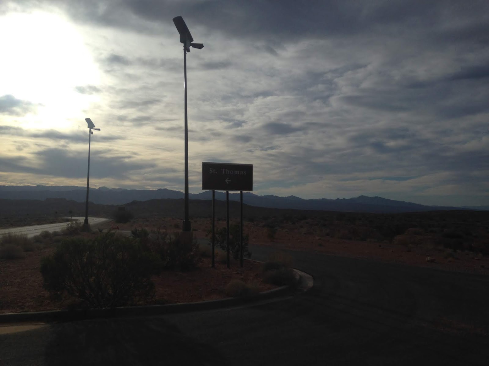
To that end the junction with Northshore Road and St. Thomas Road is located next to an entrance station for the Lake Mead National Recreation Area.


I wasn't certain of the conditions on Old St. Thomas Road and I had been advised that they were questionable at best. The previous night I calculated the distance between Northshore Road and St. Thomas to be approximately a 8 mile round-trip which I would attempt to run if I got out early enough. I encountered a driver coming back from St. Thomas who confirmed that a minimum a high clearance vehicle would likely be needed to reach the town site.

St. Thomas could faintly be seen off in the distance thanks to a low water level in Lake Mead revealing the confluence of the Muddy River and Virgin River. I had already hiked several miles in Valley of Fire State Park but figured I would try to get as far as I could safely down Old St. Thomas Road running.

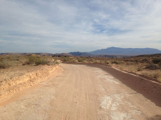
Conditions on Old St. Thomas Road weren't the best for running or driving a low clearance vehicle with various deep ruts and dips in the road surface. I made it about 2.5 miles from Northshore Road before I decided to turn back towards my car.


On the way back to Northshore Road I found that Old St. Thomas Road had a hell of a view of Valley of Fire State Park to the west.

Another interesting discovery I found on Old St. Thomas Road was that the dirt surface was covering asphalt. It seems that even by the 1930s access to St. Thomas on NV 12 was paved.


Northeast of Lake Mead it seems that NV 12 once followed St. Thomas Gap Road into Arizona. On the Arizona Side of the State Line there never was a counter part state route in Mohave County on the Arizona Strip. Either way its that Nevada invested so heavily into building a road past St. Thomas to an empty part of Arizona.
Part 9 of this series is about the Virgin River Gorge section of Interstate 15 which can be found here:
2016 Fall Mountain Trip Part 9; Interstate 15 in the Virgin River Gorge

All of current NV 169 once part of NV 12 and presently ends at the boundary of Lake Mead National Recreation Area just north of Valley of Fire Highway. That said NV 12 originally continued further south east to the ghost town St. Thomas and the Arizona State Line. NV 12 first appears on the 1929 Nevada State Highway Map.
1929 Nevada State Highway Map
St. Thomas was an extremely rural community located in far flung Clark County near the confluence of the Muddy River and Virgin River. St. Thomas was settled by Mormon pioneers in 1865 in what was Mohave County of the Arizona Territory. The northern most section of Mohave County would be split into Pah-Ute County in December 1865 and St. Thomas became the second County Seat in 1867. By 1871 a large portion of Pah-Ute County which included St. Thomas was shifted via survey to the State of Nevada. The remaining parts of Pah-Ute County in Arizona were dissolved and merged back into Mohave County.
The State of Nevada attempted to levy back taxes against the residents of St. Thomas which led the Mormon settlers to abandoned it later in 1871. Nevadans would quickly repopulate the abandoned St. Thomas and continued to occupy the site until the waters of Lake Mead began to rise behind the Hoover Dam. The last resident of St. Thomas was forced to leave the community in 1938. At the time the Hoover Dam was complete it was thought that St. Thomas would never be below water ever again, time has shown that assumption to be false.
The Hoover Dam was completed in 1936 and had a fairly obvious effect on NV 12 given it was to flood out St. Thomas. On the 1935 State Highway Map NV 12 can be seen as a completed route but by 1937 Lake Mead had expanded far enough northward that the route was cut in two.
1935 Nevada State Highway Map
1937 Nevada State Highway Map
By 1939 the split NV 12 was resolved when the route ended at the Lake Mead National Recreation Area. I can't confirm it but this appears to be when NV 12 was shifted to a terminus at Overton Beach Marina on Overton Beach Marina Road.
1939 Nevada State Highway Map
I'm uncertain when or if NV 169 was ever applied to Overton Beach Road, it doesn't appear that it was signed after the 1976 State Highway Numbers were applied state wide.
To that end the junction with Northshore Road and St. Thomas Road is located next to an entrance station for the Lake Mead National Recreation Area.

I wasn't certain of the conditions on Old St. Thomas Road and I had been advised that they were questionable at best. The previous night I calculated the distance between Northshore Road and St. Thomas to be approximately a 8 mile round-trip which I would attempt to run if I got out early enough. I encountered a driver coming back from St. Thomas who confirmed that a minimum a high clearance vehicle would likely be needed to reach the town site.

St. Thomas could faintly be seen off in the distance thanks to a low water level in Lake Mead revealing the confluence of the Muddy River and Virgin River. I had already hiked several miles in Valley of Fire State Park but figured I would try to get as far as I could safely down Old St. Thomas Road running.

Conditions on Old St. Thomas Road weren't the best for running or driving a low clearance vehicle with various deep ruts and dips in the road surface. I made it about 2.5 miles from Northshore Road before I decided to turn back towards my car.


On the way back to Northshore Road I found that Old St. Thomas Road had a hell of a view of Valley of Fire State Park to the west.

Another interesting discovery I found on Old St. Thomas Road was that the dirt surface was covering asphalt. It seems that even by the 1930s access to St. Thomas on NV 12 was paved.


Northeast of Lake Mead it seems that NV 12 once followed St. Thomas Gap Road into Arizona. On the Arizona Side of the State Line there never was a counter part state route in Mohave County on the Arizona Strip. Either way its that Nevada invested so heavily into building a road past St. Thomas to an empty part of Arizona.
Part 9 of this series is about the Virgin River Gorge section of Interstate 15 which can be found here:
2016 Fall Mountain Trip Part 9; Interstate 15 in the Virgin River Gorge
Comments