Given that I was leaving Zion National Park an hour or so before sundown south towards Las Vegas on Interstate 15 it gave me an opportunity to take pictures of the 30 miles of the route in Arizona. This particular section of I-15 is notable for being on the Arizona Strip north of the Grand Canyon and of course due to the routing through the Virgin River Gorge.

The Arizona Strip is a section of Mohave and Yavapai Counties which are cut-off from the rest of Arizona by the Grand Canyon. I-15 within Arizona is located entirely in Mohave County despite it not being even anywhere close any of it's major cities like Kingman, Bullhead City, or Lake Havasu City. The isolation from the rest of Arizona has led the communities present to share much more in common with Utah (which was really bad in the case of Colorado City).
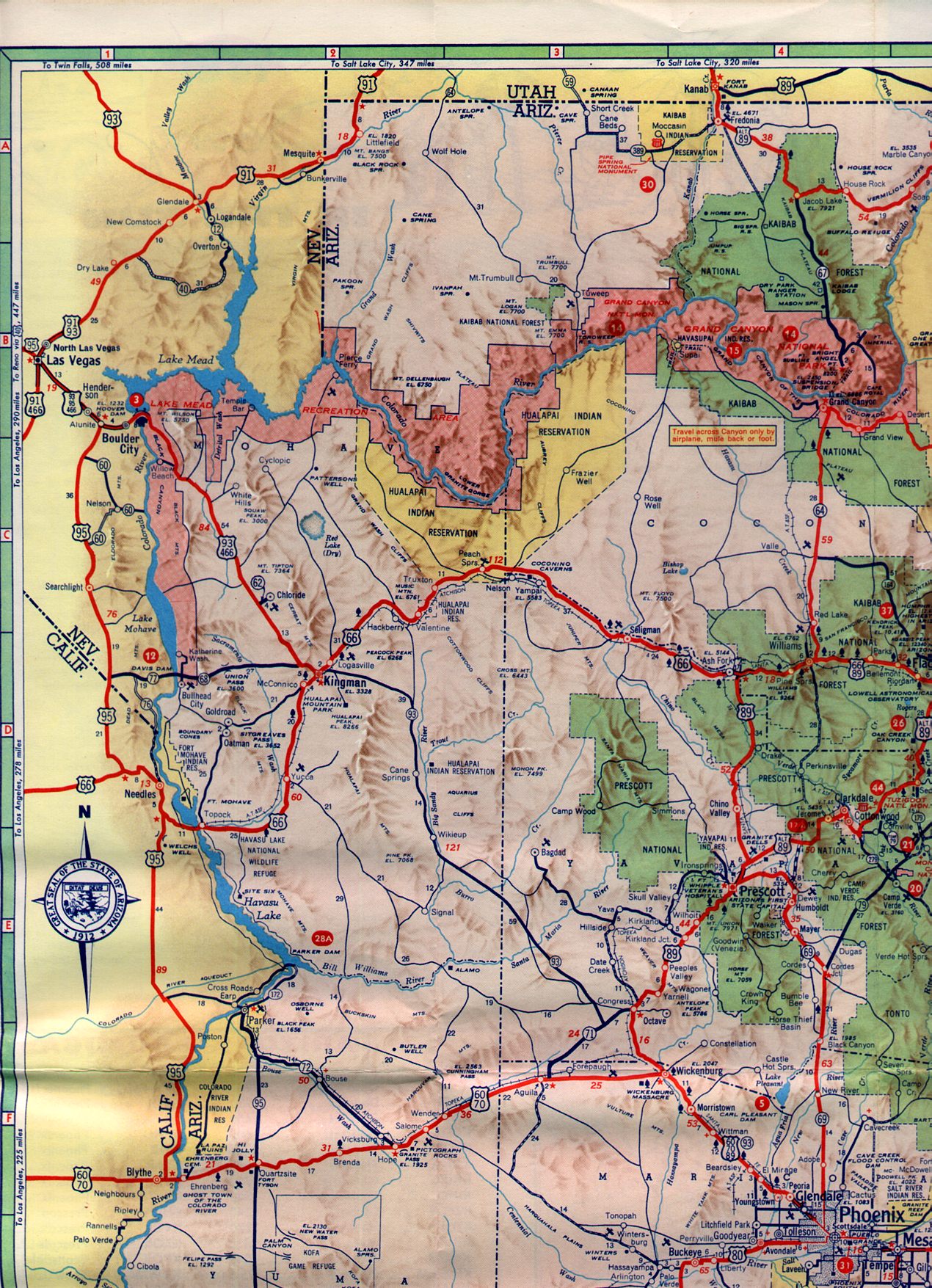
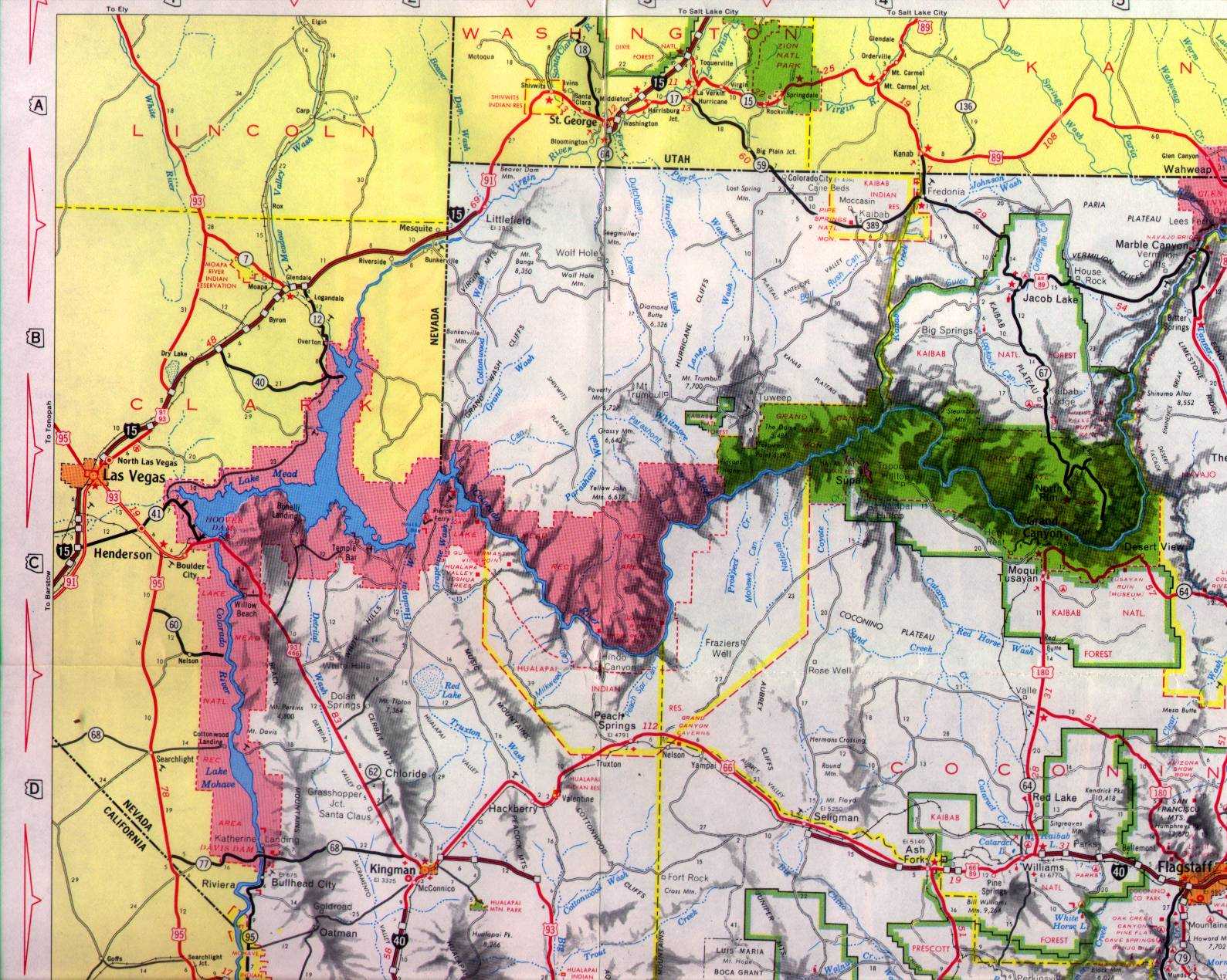
Unlike US Route 91 which dipped into Utah upstream on the Virgin River the routing of I-15 was constructed through the Virgin River Gorge to save approximately 12 miles. Despite the canyon depths the Virgin River Gorge was found to have more shallow grades than the alignment of US 91. I-15 was under construction in Arizona from the early 1960s until it was completed in 1973. The northwest corner of the Arizona state highway maps in 1961 and 1971 show the progression from US 91 to an almost complete I-15.
1961 Arizona State Highway Map
1971 Arizona State Highway Map
The 2016 Arizona Department of Transportation web map book shows how different the route of I-15 is compared to US 91.
2016 ADOT Map Book
So with all that in mind I-15 is one of the best sections of Interstate in the country for scenery in Arizona. The Virgin River gorge is narrow and steep much like Zion Canyon upstream but has completely colors. This particular section of Interstate is so interesting that I often pass up a drive on a historical section of US 91 just to drive it.
Entering Arizona southbound from Utah traffic is greeted with the standard "Welcome to Arizona" sign.

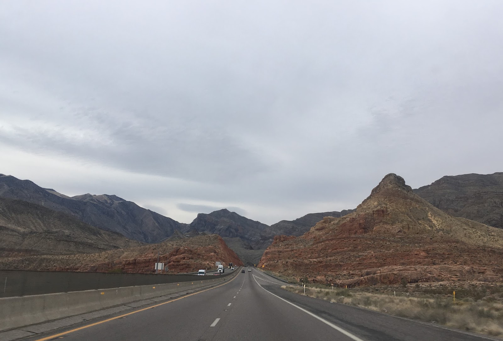
Approaching the Virgin River Gorge traffic is warned about the down hill descent.

There was actually a snow advisory for Saturday which found odd considering that the weather was nearing 70F in Zion. The Arizona Centennial signs from 2012 seem to be holding up well over time.

Black Rock Road can be reached via exit 27.

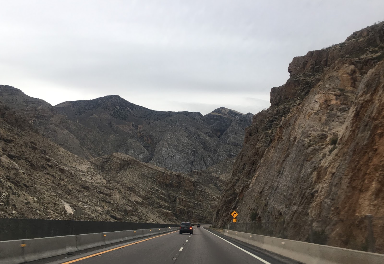
Signage is posted southbound indicating that you are traveling through the Virgin River Gorge.

I-15 in Arizona was recently reconstructed. The speed limit in the Virgin River Gorge dips down to 55 MPH but I found that to be grossly inadequate. I was having my doors blown off by traffic going close to 80 MPH when I was at leisurely speeds like 65-70 MPH. I-15 crosses over the Virgin River numerous times and even has a dedicated recreation exit at mile marker 18 for Cedar Pocket. The western end of the Gorge is far abrupt than from the east.


Exiting the Virgin River Gorge the terrain on I-15 flattens back out and 75 MPH speeds resume.

Exit 8 accesses County Route 91 which is the old alignment of US 91. US 91 continued northward to Utah and ran south of I-15 into Nevada.

Exiting Arizona I-15 enters Nevada and Clark County. Much of Old US 91 is now signed as the I-15 Business Loop. I missed the "Welcome to Nevada" sign due to motion blur from going 80 MPH.

ADOT actually has a Youtube Channel which has videos on the rehab project in the Virgin River Gorge which started in 2014 and went through to 2016:
The Arizona Strip is a section of Mohave and Yavapai Counties which are cut-off from the rest of Arizona by the Grand Canyon. I-15 within Arizona is located entirely in Mohave County despite it not being even anywhere close any of it's major cities like Kingman, Bullhead City, or Lake Havasu City. The isolation from the rest of Arizona has led the communities present to share much more in common with Utah (which was really bad in the case of Colorado City).
Unlike US Route 91 which dipped into Utah upstream on the Virgin River the routing of I-15 was constructed through the Virgin River Gorge to save approximately 12 miles. Despite the canyon depths the Virgin River Gorge was found to have more shallow grades than the alignment of US 91. I-15 was under construction in Arizona from the early 1960s until it was completed in 1973. The northwest corner of the Arizona state highway maps in 1961 and 1971 show the progression from US 91 to an almost complete I-15.
1961 Arizona State Highway Map
1971 Arizona State Highway Map
The 2016 Arizona Department of Transportation web map book shows how different the route of I-15 is compared to US 91.
2016 ADOT Map Book
So with all that in mind I-15 is one of the best sections of Interstate in the country for scenery in Arizona. The Virgin River gorge is narrow and steep much like Zion Canyon upstream but has completely colors. This particular section of Interstate is so interesting that I often pass up a drive on a historical section of US 91 just to drive it.
Entering Arizona southbound from Utah traffic is greeted with the standard "Welcome to Arizona" sign.

Approaching the Virgin River Gorge traffic is warned about the down hill descent.

There was actually a snow advisory for Saturday which found odd considering that the weather was nearing 70F in Zion. The Arizona Centennial signs from 2012 seem to be holding up well over time.

Black Rock Road can be reached via exit 27.

Signage is posted southbound indicating that you are traveling through the Virgin River Gorge.

I-15 in Arizona was recently reconstructed. The speed limit in the Virgin River Gorge dips down to 55 MPH but I found that to be grossly inadequate. I was having my doors blown off by traffic going close to 80 MPH when I was at leisurely speeds like 65-70 MPH. I-15 crosses over the Virgin River numerous times and even has a dedicated recreation exit at mile marker 18 for Cedar Pocket. The western end of the Gorge is far abrupt than from the east.


Exiting the Virgin River Gorge the terrain on I-15 flattens back out and 75 MPH speeds resume.

Exit 8 accesses County Route 91 which is the old alignment of US 91. US 91 continued northward to Utah and ran south of I-15 into Nevada.

Exiting Arizona I-15 enters Nevada and Clark County. Much of Old US 91 is now signed as the I-15 Business Loop. I missed the "Welcome to Nevada" sign due to motion blur from going 80 MPH.

ADOT actually has a Youtube Channel which has videos on the rehab project in the Virgin River Gorge which started in 2014 and went through to 2016:
Comments