The final part of the 2012 was the Overseas Highway segment of US 1.

The endpoint of the 2012 Florida Trip was my drive on US 1 on the Overseas Highway. Less than a year later I would find myself ironically being offered work in the Lower Florida Keys. To that end I was looking greatly forward to driving the Overseas Highway but didn't know anything approaching what I do now about it's back story. For an infinitely more complete version of US 1 on the Overseas Highway and the precursor Florida State 4a I would suggest reading my recent blog on those topics from 2017:
2017 Southeast Road Trip Part 13; US 1 the Overseas Highway and the Legacy of Florida State Road 4a
I started the morning out somewhat early to make it down from downtown Miami to the 18 Mile Stretch of the Overseas Highway. Relatively quickly I found myself crossing Jewfish Creek onto Key Largo.


At the time I wasn't exactly familiar with US 1 on the Overseas Highway so I tried to capture all the placards displaying the names of each Key as I crossed onto them. I was nowhere near as proficient at road photos back in those days but I managed some "acceptable" pictures like these of the Channel Five bridge between Craig Key and Fiesta Key which I've hung onto over the years.


The Long Key Viaduct approaching Duck Key.

I stopped in Marathon for breakfast somewhere north of the airport. I've never been able to find the place since but it had a small bay really good food. Apparently the owners had problems with people feeding their Iguana which I find odd considering how much some of the locals hate them due to being a invasive species in the Keys.

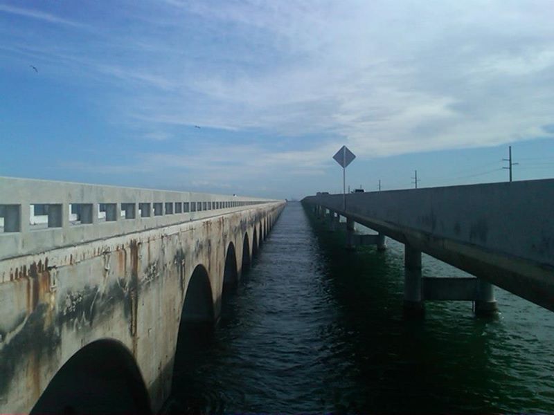
I did have some decent shots from the Seven Mile Bridge but missed the really good parking lot that has access to Pigeon Key on the Marathon Side. I stopped on Little Duck Key to get some photos of the south side of both Seven Mile Bridges.


The next stop was on Spanish Harbor Key to check out the south side of the gapped Bahia Honda Key Bridge. I still think these were some of my better photos of the bridge and I recently used some of them in the 2017 blog.


Never saw a Key Deer on Big Pine Key back in 2012.

We did stop at Mangrove Mama's on Sugarloaf Key. I later found out when I moved to the Keys that the parking lot literally was an abandoned section of Florida State Road 4a. Odd to think that I actually ran that old highway almost every day. Upon arriving in Key West I found that US 1 was routed one-way southbound which meant a detour through the city on Flagler. Since this was a family trip we did all the tourist oriented stuff like Fort Zachery Taylor, the Southernmost Point, the Key West Lighthouse, the Hemmingway House, Mallory Square, and Duval Street.


Funny, I don't seem to recall actually taking a picture of the "US 1 END MILE MARKER 0" sign assembly which is a travesty considering my photos were largely road oriented. Suffice to say I made a ton of improvements to my photos and learned a lot more about the Overseas Highway which led to the 2017 "Magnum Opus" of a road album. I'm not sure when I'll be back to Key West or the Overseas Highway again but it is fun to revisit some old memories of a 2012 family trip.

The endpoint of the 2012 Florida Trip was my drive on US 1 on the Overseas Highway. Less than a year later I would find myself ironically being offered work in the Lower Florida Keys. To that end I was looking greatly forward to driving the Overseas Highway but didn't know anything approaching what I do now about it's back story. For an infinitely more complete version of US 1 on the Overseas Highway and the precursor Florida State 4a I would suggest reading my recent blog on those topics from 2017:
2017 Southeast Road Trip Part 13; US 1 the Overseas Highway and the Legacy of Florida State Road 4a
I started the morning out somewhat early to make it down from downtown Miami to the 18 Mile Stretch of the Overseas Highway. Relatively quickly I found myself crossing Jewfish Creek onto Key Largo.


At the time I wasn't exactly familiar with US 1 on the Overseas Highway so I tried to capture all the placards displaying the names of each Key as I crossed onto them. I was nowhere near as proficient at road photos back in those days but I managed some "acceptable" pictures like these of the Channel Five bridge between Craig Key and Fiesta Key which I've hung onto over the years.


The Long Key Viaduct approaching Duck Key.

I stopped in Marathon for breakfast somewhere north of the airport. I've never been able to find the place since but it had a small bay really good food. Apparently the owners had problems with people feeding their Iguana which I find odd considering how much some of the locals hate them due to being a invasive species in the Keys.

I did have some decent shots from the Seven Mile Bridge but missed the really good parking lot that has access to Pigeon Key on the Marathon Side. I stopped on Little Duck Key to get some photos of the south side of both Seven Mile Bridges.


The next stop was on Spanish Harbor Key to check out the south side of the gapped Bahia Honda Key Bridge. I still think these were some of my better photos of the bridge and I recently used some of them in the 2017 blog.


Never saw a Key Deer on Big Pine Key back in 2012.

We did stop at Mangrove Mama's on Sugarloaf Key. I later found out when I moved to the Keys that the parking lot literally was an abandoned section of Florida State Road 4a. Odd to think that I actually ran that old highway almost every day. Upon arriving in Key West I found that US 1 was routed one-way southbound which meant a detour through the city on Flagler. Since this was a family trip we did all the tourist oriented stuff like Fort Zachery Taylor, the Southernmost Point, the Key West Lighthouse, the Hemmingway House, Mallory Square, and Duval Street.


Funny, I don't seem to recall actually taking a picture of the "US 1 END MILE MARKER 0" sign assembly which is a travesty considering my photos were largely road oriented. Suffice to say I made a ton of improvements to my photos and learned a lot more about the Overseas Highway which led to the 2017 "Magnum Opus" of a road album. I'm not sure when I'll be back to Key West or the Overseas Highway again but it is fun to revisit some old memories of a 2012 family trip.
Comments