I had some time to kill this morning and decided to try the Fresno County Blossom Trail.

The Blossom Trail is a 62 mile signed Auto Touring Route in Central Fresno County. The Blossom Trail is in it's 30th Anniversary year and is signed by the Fresno County Office of Tourism. The Blossom Trail is essentially meant to bring tourism to the rural farm industry when the plants are beginning to bloom and after they have been harvested. The bloom hit early this year due to favorable weather which was more than enough incentive for me to explore some rural areas I haven't been to yet. I started out at the intersection of Jensen Avenue and Clovis Avenue.

The Blossom Trail starts and ends at Simonian Farms which is at the southeast side of the Clovis/Jensen intersection.

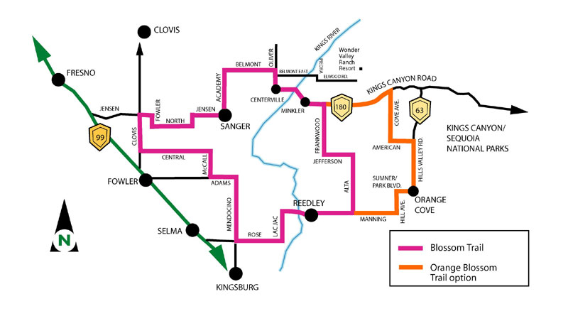
The Fresno County Office of Tourism has a map of the Blossom Trail on their website. The route is largely rural and avoids directly running through most towns.
Map of the Blossom Trail
The Fresno County Office of Tourism also has a website directly dedicated to the Blossom Trail.
Goblossomtrail.com
With all that in mind Simonian Farms was closed until 9 AM so made a southward turn on Clovis Avenue.

The Blossom Trail is only on the four lane Clovis Avenue for two miles south before turning west on Central Avenue.

There isn't anything too exciting on Central Avenue aside from a bunch of open "Flooded" cautionary signs. The roadway wasn't flooded nor was there any standing water in the immediate area, the winter in California has been surprisingly dry compared to last year.

The Blossom Trail turns south McCall Avenue. Already I was seeing a theme with how well the Blossom Trail is signed despite vinyl shields being used.


The first major group of blossoms was on McCall Avenue, I'm not an agriculture expert but I believe these are apricots?

Fresno County in general has good signage standards on rural roadways. There are green guide signs pretty much at every significant junction showing control cities.

The next turn on the Blossom Trail is west on Adams Avenue.


There wasn't too much to see on Adams and the next turn on the Blossom Trail was south on Mendocino Avenue.


Immediately to my right was more apricot blossoms.

The Blossom Trail continues south through Parlier on Mendocino Avenue. Parlier dates back to the 1870s and was once on the Visalia District branch operated by the ATSF (Atchison, Topeka and Santa Fe) Railroad. The community has essentially always has has agriculturally based economy.


The next turn on the Blossom Trail is east on Rose Avenue.


The Blossom Trail continues east to Lac Jac Avenue which swings north to Manning Avenue. Lac Jac Avenue is the name of a ATSF rail siding town which used to be directly north of Manning Avenue.


Manning Avenue east of California State Route 99 is a high quality expressway. The Blossom Trail travels over the Kings River entering the city of Reedley on Manning Avenue.


The Blossom Trail stays on Manning Avenue which essentially bypasses downtown to the north. There is a small trail along the BNSF rails which traverse downtown Reedley. Reedley was founded as a rail siding town in the late 1880s.


The Blossom Trail continues east on Manning Avenue to Alta Avenue where it turns north. The Orange Blossom Trail begins at the junction with Manning and Alta which continues east to Orange Cove.


North on Alta Avenut I found this odd CA 180 shield with reverse colors and strange font. It almost resembled the Santa Clara County sourced CA 130 shields on San Antonio Valley Road.


The Blossom Trail next turns west on Jefferson Avenue within view of the Sierra Foothills.


Jefferson is the only single lane portion of the Blossom Trail. The narrow portion on Jefferson ends at a northward turn on Frankwood Avenue.


Frankwood Avenue has a nice view overlooking the Sierra Foothills before meeting CA 180.

The Blossom Trail makes a western turn at CA 180/Kings Canyon Road. Oddly the only missing Blossom Trail sign was located at the junction of Kings Canyon and Frankwood, the Orange Blossom Trail loops back to it's parent trail at this junction as well. The Schoolhouse Restaurant is located on the southeast side of the Kings Canyon/Frankwood Junction. The schoolhouse was originally the Frankwood School which was the second school house on the site with the current structure being built in 1921. The Frankwood School was shuttered in 1958 having been absorbed into the Centerville School District.


The Blossom Trail continues westward on CA 180 into Minkler. I found a stray County Route shaped scenic placard entering Minkler westbound.


I wrote about Minkler on a previous blog and I'll just borrow what I already wrote about it:
"Minkler was essentially a rail siding that was created back in 1920. Back in the hey day of Minkler it was located at the junction of the Wahtoke District Railroad and Porterville-Orosi District Railroad. The Wahotke District Railroad used to travel north on the Kings River towards Piedra which terminated at a local rock quarry. Both lines were abandoned in the 1960s and 1970s."
"Today there are only a couple structures in Minkler still inhabited. One of them on the south side of CA 180 is called the Minkler Cash Store is reportedly a place where locals just basically regale tourists and people passing by about local lore."
Speaking of the Minkler Cash Store it truly is a throwback to a bygone era.


West of Minkler on CA 180/Blossom Trail the new bypass alignment of Centerville could be seen under construction crossing the Kings River.


In Centerville the Blossom Trail turns north on Oliver Avenue, apparently bunnies were for sale.

Much like Minkler I wrote a blog entry previously about Centerville:
"Centerville actually is one of the oldest communities in what is now Fresno County having been founded back in 1854 as Scottsburg. By 1858 Poole's Ferry was established as a crossing of the Kings River which was part of the Stockton-Los Angeles Road which had only been created five years prior. The original town site was destroyed in a flood in 1867 and it was resettled to the west as Centerville in the present location. Centerville has approximately 400 residents according to the 2010 census but I'm not sure what area that figure actually consists of."
For such a historically significant locale there isn't much left of Centerville today. There are some structures that still line CA 180 that are obviously from much better times when Centerville was actually important.


An 1891 map of Centerville shows much of the community has disappeared. I'm fairly certain that Cross Street is now CA 180. Incidentally I wrote a blog about the crossing of the Kings River in Kingston which no longer exists nor is in Fresno County anymore.
1891 Map of Centerville
On Oliver Avenue I pulled over to look at the new CA 180 bypass of Centerville under construction.


On Oliver there is a large culvert that was designed some time between the 1920s to 1940s. Fresno County has a ton of these older culverts which are usually painted solid white.

The Blossom Trail turns west on Belmont Avenue.

Followed by a southward turn on Academy Avenue which just so happened to have a large tract of blossoms.


The Blossom Trail follows Academy Avenue south to the City of Sanger and takes a westward turn at Jensen Avenue.


The Blossom Trail continues west out of Sanger and turns south on McCall Avenue.


The Blossom Trail is only on McCall for one mile before turning west again on North Avenue.


The Blossom Trail turns north on Fowler Avenue.


The Blossom Trail crosses paths with the former Visalia District Railroad right-of-way and a former Rail Siding site known as Lone Star. Lone Star can be noted by the name of a nearby school and the really obvious ATSF station in a packing yard.


A map of the Visalia District Railroad can be found on Abandoned Rails:
Visalia District Railroad Map
Additional Rail Sidings such as; Cecile, Wolf, and Lac Jac can be seen between Fresno east to Reedley on the Visalia District Railroad on the 1935 California Division of Highways Map of Fresno County.
1935 Fresno County Highway Map
The Blossom Trail turns west on Jensen before terminating at Simonian Farms after a mile.


Simonian Farms dates back to 1901 which likely was due to the Visalia District Railroad. Simonian Farms has a ton of old farm equipment, rail equipment, gas/oil signs, and even some old highway traffic control signs. There is plenty of fruit displays and even ice cream to purchase as well. I usually stop in now and then to see if any California State Highway shields have popped up for sale.


The Blossom Trail is a 62 mile signed Auto Touring Route in Central Fresno County. The Blossom Trail is in it's 30th Anniversary year and is signed by the Fresno County Office of Tourism. The Blossom Trail is essentially meant to bring tourism to the rural farm industry when the plants are beginning to bloom and after they have been harvested. The bloom hit early this year due to favorable weather which was more than enough incentive for me to explore some rural areas I haven't been to yet. I started out at the intersection of Jensen Avenue and Clovis Avenue.

The Blossom Trail starts and ends at Simonian Farms which is at the southeast side of the Clovis/Jensen intersection.

The Fresno County Office of Tourism has a map of the Blossom Trail on their website. The route is largely rural and avoids directly running through most towns.
Map of the Blossom Trail
The Fresno County Office of Tourism also has a website directly dedicated to the Blossom Trail.
Goblossomtrail.com
With all that in mind Simonian Farms was closed until 9 AM so made a southward turn on Clovis Avenue.

The Blossom Trail is only on the four lane Clovis Avenue for two miles south before turning west on Central Avenue.

There isn't anything too exciting on Central Avenue aside from a bunch of open "Flooded" cautionary signs. The roadway wasn't flooded nor was there any standing water in the immediate area, the winter in California has been surprisingly dry compared to last year.

The Blossom Trail turns south McCall Avenue. Already I was seeing a theme with how well the Blossom Trail is signed despite vinyl shields being used.


The first major group of blossoms was on McCall Avenue, I'm not an agriculture expert but I believe these are apricots?

Fresno County in general has good signage standards on rural roadways. There are green guide signs pretty much at every significant junction showing control cities.

The next turn on the Blossom Trail is west on Adams Avenue.


There wasn't too much to see on Adams and the next turn on the Blossom Trail was south on Mendocino Avenue.


Immediately to my right was more apricot blossoms.

The Blossom Trail continues south through Parlier on Mendocino Avenue. Parlier dates back to the 1870s and was once on the Visalia District branch operated by the ATSF (Atchison, Topeka and Santa Fe) Railroad. The community has essentially always has has agriculturally based economy.


The next turn on the Blossom Trail is east on Rose Avenue.


The Blossom Trail continues east to Lac Jac Avenue which swings north to Manning Avenue. Lac Jac Avenue is the name of a ATSF rail siding town which used to be directly north of Manning Avenue.


Manning Avenue east of California State Route 99 is a high quality expressway. The Blossom Trail travels over the Kings River entering the city of Reedley on Manning Avenue.


The Blossom Trail stays on Manning Avenue which essentially bypasses downtown to the north. There is a small trail along the BNSF rails which traverse downtown Reedley. Reedley was founded as a rail siding town in the late 1880s.


The Blossom Trail continues east on Manning Avenue to Alta Avenue where it turns north. The Orange Blossom Trail begins at the junction with Manning and Alta which continues east to Orange Cove.


North on Alta Avenut I found this odd CA 180 shield with reverse colors and strange font. It almost resembled the Santa Clara County sourced CA 130 shields on San Antonio Valley Road.


The Blossom Trail next turns west on Jefferson Avenue within view of the Sierra Foothills.


Jefferson is the only single lane portion of the Blossom Trail. The narrow portion on Jefferson ends at a northward turn on Frankwood Avenue.


Frankwood Avenue has a nice view overlooking the Sierra Foothills before meeting CA 180.

The Blossom Trail makes a western turn at CA 180/Kings Canyon Road. Oddly the only missing Blossom Trail sign was located at the junction of Kings Canyon and Frankwood, the Orange Blossom Trail loops back to it's parent trail at this junction as well. The Schoolhouse Restaurant is located on the southeast side of the Kings Canyon/Frankwood Junction. The schoolhouse was originally the Frankwood School which was the second school house on the site with the current structure being built in 1921. The Frankwood School was shuttered in 1958 having been absorbed into the Centerville School District.


The Blossom Trail continues westward on CA 180 into Minkler. I found a stray County Route shaped scenic placard entering Minkler westbound.


I wrote about Minkler on a previous blog and I'll just borrow what I already wrote about it:
"Minkler was essentially a rail siding that was created back in 1920. Back in the hey day of Minkler it was located at the junction of the Wahtoke District Railroad and Porterville-Orosi District Railroad. The Wahotke District Railroad used to travel north on the Kings River towards Piedra which terminated at a local rock quarry. Both lines were abandoned in the 1960s and 1970s."
"Today there are only a couple structures in Minkler still inhabited. One of them on the south side of CA 180 is called the Minkler Cash Store is reportedly a place where locals just basically regale tourists and people passing by about local lore."
Speaking of the Minkler Cash Store it truly is a throwback to a bygone era.


West of Minkler on CA 180/Blossom Trail the new bypass alignment of Centerville could be seen under construction crossing the Kings River.


In Centerville the Blossom Trail turns north on Oliver Avenue, apparently bunnies were for sale.

Much like Minkler I wrote a blog entry previously about Centerville:
"Centerville actually is one of the oldest communities in what is now Fresno County having been founded back in 1854 as Scottsburg. By 1858 Poole's Ferry was established as a crossing of the Kings River which was part of the Stockton-Los Angeles Road which had only been created five years prior. The original town site was destroyed in a flood in 1867 and it was resettled to the west as Centerville in the present location. Centerville has approximately 400 residents according to the 2010 census but I'm not sure what area that figure actually consists of."
For such a historically significant locale there isn't much left of Centerville today. There are some structures that still line CA 180 that are obviously from much better times when Centerville was actually important.


An 1891 map of Centerville shows much of the community has disappeared. I'm fairly certain that Cross Street is now CA 180. Incidentally I wrote a blog about the crossing of the Kings River in Kingston which no longer exists nor is in Fresno County anymore.
1891 Map of Centerville
On Oliver Avenue I pulled over to look at the new CA 180 bypass of Centerville under construction.


On Oliver there is a large culvert that was designed some time between the 1920s to 1940s. Fresno County has a ton of these older culverts which are usually painted solid white.

The Blossom Trail turns west on Belmont Avenue.

Followed by a southward turn on Academy Avenue which just so happened to have a large tract of blossoms.


The Blossom Trail follows Academy Avenue south to the City of Sanger and takes a westward turn at Jensen Avenue.


The Blossom Trail continues west out of Sanger and turns south on McCall Avenue.


The Blossom Trail is only on McCall for one mile before turning west again on North Avenue.


The Blossom Trail turns north on Fowler Avenue.


The Blossom Trail crosses paths with the former Visalia District Railroad right-of-way and a former Rail Siding site known as Lone Star. Lone Star can be noted by the name of a nearby school and the really obvious ATSF station in a packing yard.


A map of the Visalia District Railroad can be found on Abandoned Rails:
Visalia District Railroad Map
Additional Rail Sidings such as; Cecile, Wolf, and Lac Jac can be seen between Fresno east to Reedley on the Visalia District Railroad on the 1935 California Division of Highways Map of Fresno County.
1935 Fresno County Highway Map
The Blossom Trail turns west on Jensen before terminating at Simonian Farms after a mile.


Simonian Farms dates back to 1901 which likely was due to the Visalia District Railroad. Simonian Farms has a ton of old farm equipment, rail equipment, gas/oil signs, and even some old highway traffic control signs. There is plenty of fruit displays and even ice cream to purchase as well. I usually stop in now and then to see if any California State Highway shields have popped up for sale.


Comments