
North Carolina's two new future Interstates 42 and 87 - one signed, one not yet

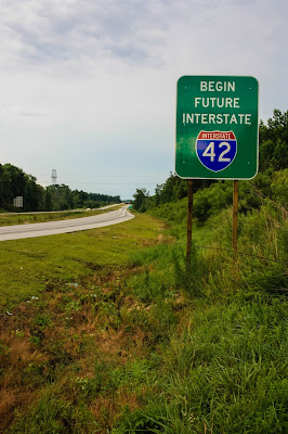
It hasn't taken North Carolina long to start putting up signs announcing the new Interstate Highways Corridors in the Eastern half of the state.  Future Interstate 42 signs are already up along US 70 from Clayton to New Bern.  Two weeks ago, I grabbed this shot on US 70 East at the start of the Clayton Bypass once you get on the highway from Interstate 40.


Signs for Future Interstate 87 aren't just ready yet.  For the past three weeks - these sign posts stand tall and alone on US 64 just east of Interstate 95 in Rocky Mount.

Now, this delay may be because NCDOT is wanting to erect the new signs and update the Future Interstate 495 signs at the same time; or who knows maybe a write-in campaign to protest the I-87 designation to the FHWA worked!

Comments

Steve Sobol saidā€¦
People seriously are complaining about the I-87 designation?
Bob Malme saidā€¦
Mostly the Roadgeek community due to either the duplication of the number, that it's more an east-west route than north-south, or both. The hold up on installing the I-87 signs may be due to the existence of I-495/Future I-495 along the corridor from Raleigh to I-95 and the need to get the FHWA and AASHTO to sign off on the decommissioning of that route before any other route number can be put up.
Anonymous saidā€¦
Yo interstate 87 end in Harlem nyc how gping have that in nc they need look for another number

Popular posts from this blog

Hawaii Route 8930

Hawaii Route 8930 is a 2.5-mile State Highway on the Island of O'hau.  Hawaii Route 8930 is aligned over Kualakai Parkway over the course of its entire alignment south from Interstate H-1 to Kapolei Parkway.  Hawaii Route 8930 is one of the newest Hawaii Routes only having been completed during 2010.   This page is part of the Gribblenation O'ahu Highways page.  All Gribblenation and Roadwaywiz media related to the highway system of O'ahu can be found at the link below: https://www.gribblenation.org/p/gribblenation-oahu-highways-page.html Part 1; the history of Hawaii Route 8930 The history of Hawaii Route 8930 is brief given it is a modern facility.  Hawaii Route 8930 and what was known as "North-South Road" were built to facilitate the developing areas of Kapolei on western O'ahu.  According to hawaiihighways.com the first stage of Hawaii Route 8930 was completed from Kapolei Parkway north to Farrington Highway as a four-lane highway during November...

Madera County Road 607 and the Stockton-Los Angeles Road

Madera County Road 607 is an approximately seven-mile rural unsurfaced highway which spans from Road 600 near Raymond west to Road 29.   Road 607 west from Raymond Road Cemetery (established in 1905) is part of the Stockton-Los Angeles Road corridor surveyed in 1853. The corridor lies in the gap between Fresno Crossing at the Fresno River west to Newton's Crossing at the Chowchilla River. The Buchanan Copper Mine would be along what is now Road 607 in the namesake Buchanan Hollow during July 1863. The Buchanan Mine is thought to have once had a population of between 1,000-1,500 residents by the early 1870s. Copper prices would decline in the decade after the Civil War and much of the activity at Buchanan shifted towards cattle ranching. The last businesses in the community would shutter during World War II and it is now a true ghost town. Part 1; the history of Madera County Road 607 and the Stockton-Los Angeles Road What is now Road 607 was a component of the larger Sto...

Paper Highways; Interstate H-4 through downtown Honolulu

The Hawaiian Island of O'ahu is home to four Interstate Highways; H-1, H-2, H-3 and H-201.  Had history gone slightly differently during the 1960s a fifth Interstate corridor on O'ahu could have been constructed through downtown Honolulu and the neighborhood of Waikiki.  The proposed corridor of Interstate H-4 can be seen above as it was presented by the Hawaii Department of Transportation during October 1968 .   This page is part of the Gribblenation O'ahu Highways page.  All Gribblenation and Roadwaywiz media related to the highway system of O'ahu can be found at the link below: https://www.gribblenation.org/p/gribblenation-oahu-highways-page.html The history of proposed Interstate H-4 The corridor of Interstate H-4 was conceived as largely following what is now Hawaii Route 92 on Nimitz Highway and Ala Moana Boulevard.   Prior to the Statehood the first signed highways within Hawaii Territory came into existence during World War II.    Dur...